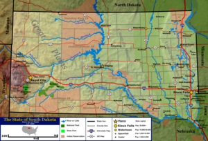
South Dakota is a state located in the north-central United States. It is usually considered to be in the Midwestern region of the country. The state can generally be divided into three geographic regions: eastern South Dakota, western South Dakota, and the Black Hills. Eastern South Dakota is lower in elevation and higher in precipitation than the western part of the state, and the Black Hills are a low, isolated mountain group in the southwestern corner of the state. Smaller sub-regions in the state include the Coteau des Prairies, Missouri Coteau, James River Valley, and the Dissected Till Plains. Geologic formations in South Dakota range in age from two billion-year-old Precambrian granite in the Black Hills to glacial till deposited over the last few million years. South Dakota is the 17th-largest state in the country.
South Dakota has a humid continental climate in the east and the Black Hills, and a semi-arid climate in the west outside of the Black Hills, featuring four very distinct seasons, and the ecology of the state features plant and animal species typical of a North American temperate grassland biome. A number of areas under the protection of the federal or state government, such as Badlands National Park, Wind Cave National Park, and Custer State Park, are located in the state.
In 2011, the population of South Dakota was estimated to be 824,082, and the state ranks fifth-lowest in both total population as well as population density in the United States. Sioux Falls, with a population of just over 200,000 is the largest city in the state. Rapid City ranks as South Dakota's second-largest city, and Pierre is the state capital. Historically a very agricultural state, the service and tourism sectors have grown in economic importance in recent years.
