Back Geologia dell'America settentrionale Italian ಉತ್ತರ ಅಮೆರಿಕದ ಭೂವಿನ್ಯಾಸ Kannada Geologia Ameryki Północnej Polish Геологія Північної Америки Ukrainian


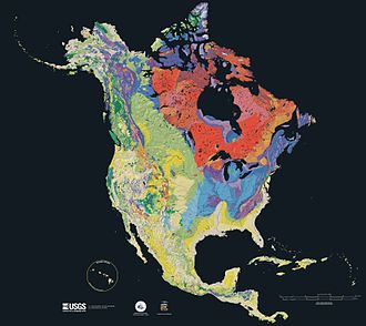
The geology of North America is a subject of regional geology and covers the North American continent, the third-largest in the world. Geologic units and processes are investigated on a large scale to reach a synthesized picture of the geological development of the continent.
The divisions of regional geology are drawn in different ways, but are usually outlined by a common geologic history, geographic vicinity or political boundaries. The regional geology of North America usually encompasses the geographic regions of Alaska, Canada, Greenland, the continental United States, Mexico, Central America, and the Caribbean.[1] The parts of the North American Plate that are not occupied by North American countries are usually not discussed as part of the regional geology. The regions that are not geographically North American but reside on the North American Plate include parts of Siberia (see the Geology of Russia),[2] and Iceland, and Bermuda. A discussion of North American geology can also include other continental plates including the Cocos and Juan de Fuca plates being subducted beneath western North America. A portion of the Pacific Plate underlies Baja California and part of California west of the San Andreas Fault.
- ^ Dengo, Gabriel; Case, James E., eds. (1990). The Caribbean Region. Decade of North American Geology, Volume H (2nd ed.). Boulder: Geological Society of America. ISBN 9780813752129.
- ^ Khain, Victor E. (1985). Geology of the USSR. Berlin: Gebr. Borntraeger. ISBN 978-3-443-11017-8.