Back غيروكسفيل (ألبرتا) Arabic جيروكسفيل ARZ Girouxville CEB گیروکسویل Persian Girouxville French Girouxville Italian Girouxville Dutch Girouxville Swedish Жирувіль Ukrainian
Girouxville | |
|---|---|
| Village of Girouxville | |
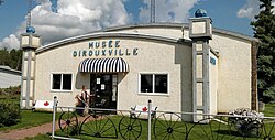
 Girouxville Museum | |
 Location in M.D. of Smoky River | |
| Coordinates: 55°45′14″N 117°20′19″W / 55.75389°N 117.33861°W | |
| Country | Canada |
| Province | Alberta |
| Region | Northern Alberta |
| Planning region | Upper Peace |
| Municipal district | Smoky River |
| Incorporated[1] | |
| • Village | December 31, 1951 |
| Government | |
| • Mayor | Joseph Zdeb |
| • Governing body | Girouxville Village Council |
| Area (2021)[2] | |
| • Land | 0.66 km2 (0.25 sq mi) |
| Elevation | 570 m (1,870 ft) |
| Population (2021)[2] | |
| • Total | 278 |
| • Density | 422.4/km2 (1,094/sq mi) |
| Time zone | UTC−7 (MST) |
| • Summer (DST) | UTC−6 (MDT) |
| Highways | Highway 49 |
| Waterway | Hunting Creek |
| Website | https://www.girouxville.ca |
Girouxville (/dʒɪˈruːvɪl/ ji-ROO-vil, Quebec French: [ʒiʁuˈvɪl]) is a village in northern Alberta, Canada. It is located 58 kilometres (36 mi) south of the Town of Peace River.
- ^ "Location and History Profile: Village of Girouxville" (PDF). Alberta Municipal Affairs. October 21, 2016. p. 316. Retrieved October 23, 2016.
- ^ a b Cite error: The named reference
2021censuswas invoked but never defined (see the help page).
