Back Giyani Afrikaans Giyani CEB Giyani German Giyani Spanish Giyani Estonian Giyani French Giyani Italian Giyani Malagasy Giyani NSO Giyani Romanian
This article has multiple issues. Please help improve it or discuss these issues on the talk page. (Learn how and when to remove these template messages)
|
Giyani | |
|---|---|
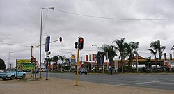
 A traffic junction and shopping centre in central Giyani | |
| Coordinates: 23°18′36″S 30°42′23″E / 23.31000°S 30.70639°E | |
| Country | South Africa |
| Province | Limpopo |
| District | Mopani |
| Municipality | Greater Giyani |
| Area | |
| • Total | 19.51 km2 (7.53 sq mi) |
| Population (2011)[1] | |
| • Total | 25,954 |
| • Density | 1,300/km2 (3,400/sq mi) |
| Racial makeup (2011) | |
| • Black African | 96.9% |
| • Coloured | 0.2% |
| • Indian/Asian | 2.0% |
| • White | 0.5% |
| • Other | 0.4% |
| First languages (2011) | |
| • XiTsonga | 91.8% |
| • English | 0.2% |
| • Northern Sotho | 2.7% |
| • TshiVenda | 1.4% |
| • Other | 6.2% |
| Time zone | UTC+2 (SAST) |
| Postal code (street) | 0826 |
| PO box | 0826 |
| Area code | 015 |
Giyani is a town situated in the north-eastern part of Limpopo Province,[2] South Africa. It is the administrative capital of the Mopani District Municipality and a former capital of the defunct Gazankulu Bantustan. The town of Giyani is divided into seven sections: Section A, Section D1, Section D2, Section E, Section F, Kremetart, and Giyani CBD. Risinga View and Church View are new residential areas in Giyani, but they fall under the local traditional leaders. The Giyani CBD is nicknamed Benstore, and this name is commonly used by residents of the region. Giyani is surrounded by a number of villages with rich Tsonga cultural activities, administered by the Greater Giyani Local Municipality.
Prof. Hudson Ntsanwisi, the former Chief Minister of Gazankulu, played a vital role in establishing the town. Giyani is situated at the intersection of R578 (South Africa) and R81. It is located in the heart of the Limpopo Bushveld, on the northern bank of the Klein Letaba River [1], west of Kruger National Park. Situated in the northern portion of the former Gazankulu, Giyani was established in the 1960s as the administrative center for the Tsonga people. Giyani lies 470 km north-east of Johannesburg by road, 104 km from Tzaneen, 105 km from the Phalaborwa Gate of the Kruger National Park, and 35 km from Malamulele.
In 1969, the Gazankulu government named a new ward at Elim Hospital 'Giyani Ward' in honor of the Gazankulu capital. The current Mayor of Greater Giyani municipality is Thandi Zitha of ANC.[3]
- ^ a b c d "Main Place Giyani". Census 2011.
- ^ "Location – Limpopo Provincial Government". www.limpopo.gov.za. Retrieved 2022-12-06.
- ^ "Greater Giyani Local Municipality | South African Government". www.gov.za. Retrieved 2024-03-31.


