Back Gooseberry Falls State Park CEB Gooseberry Falls State Park German Parc d'État de Gooseberry Falls French
| Gooseberry Falls State Park | |
|---|---|
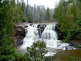
 Upper Gooseberry Falls | |
| Location | Lake, Minnesota, United States |
| Coordinates | 47°08′49″N 91°27′48″W / 47.14694°N 91.46333°W |
| Area | 1,687 acres (6.83 km2) |
| Elevation | 833 ft (254 m)[1] |
| Established | 1937 |
| Governing body | Minnesota Department of Natural Resources |
Gooseberry Falls State Park is a state park of Minnesota, United States, on the North Shore of Lake Superior. The park is located in Silver Creek Township, about 13 miles (21 km) northeast of Two Harbors, Minnesota in Lake County on scenic Minnesota Highway 61. The park surrounds the mouth of the Gooseberry River and includes Upper, Middle and Lower Gooseberry Falls.
- ^ "Gooseberry Falls State Park". Geographic Names Information System. United States Geological Survey. January 11, 1980. Retrieved February 24, 2011.

