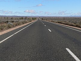
Goyder Highway | |
|---|---|
 | |
| Goyder Highway northwest of Morgan | |
| Coordinates | |
| General information | |
| Type | Highway |
| Length | 266 km (165 mi)[1] |
| Route number(s) | |
| Former route number | |
| Major junctions | |
| West end | Crystal Brook, South Australia |
| East end | Monash, South Australia |
| Location(s) | |
| Region | Yorke and Mid North, Murray and Mallee[2] |
| Major settlements | Crystal Brook, Spalding, Burra, Morgan |
| Highway system | |
| ---- | |
Goyder Highway (B64) is a west–east link through the Mid North region of South Australia connecting Spencer Gulf to the Riverland. It is part of the most direct road route from Port Augusta (and areas beyond including Eyre Peninsula, Western Australia and the Northern Territory) to much of Victoria and southern New South Wales.
- ^ "Wilkins Highway" (Map). Google Maps. Retrieved 2 June 2022.
- ^ "Location SA Map viewer with regional layers". Government of South Australia. Retrieved 16 June 2022.

