Back مقاطعة غرايسون (كنتاكي) Arabic Grayson County, Kentucky BAR Грейсън (окръг, Кентъки) Bulgarian গ্রেসন কাউন্টি, কেন্টাকি BPY Grayson Gông (Kentucky) CDO Грейсон (гуо, Кентукки) CE Grayson County (kondado sa Tinipong Bansa, Kentucky) CEB Grayson County, Kentucky Welsh Grayson County (Kentucky) German Condado de Grayson (Kentucky) Spanish
Grayson County | |
|---|---|
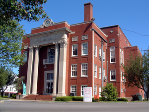
 Grayson County courthouse in Leitchfield | |
 Location within the U.S. state of Kentucky | |
 Kentucky's location within the U.S. | |
| Coordinates: 37°28′N 86°21′W / 37.46°N 86.35°W | |
| Country | |
| State | |
| Founded | 1810 |
| Named for | William Grayson |
| Seat | Leitchfield |
| Largest city | Leitchfield |
| Area | |
| • Total | 511 sq mi (1,320 km2) |
| • Land | 497 sq mi (1,290 km2) |
| • Water | 14 sq mi (40 km2) 2.8% |
| Population (2020) | |
| • Total | 26,420 |
| • Estimate (2023) | 26,825 |
| • Density | 52/sq mi (20/km2) |
| Time zone | UTC−6 (Central) |
| • Summer (DST) | UTC−5 (CDT) |
| Congressional district | 2nd |
| Website | graysoncountyky |
Grayson County is a county located in the U.S. state of Kentucky. As of the 2020 census, the population was 26,420.[1] Its county seat is Leitchfield.[2] The county was formed in 1810 and named for William Grayson (1740–1790), a Revolutionary War colonel and a prominent Virginia political figure. Grayson County was formerly a prohibition or dry county, but Leitchfield allowed limited alcohol sales in restaurants in 2010[3] and voted "wet" in 2016.[4]
- ^ "State & County QuickFacts". United States Census Bureau. Retrieved August 14, 2022.
- ^ "Find a County". National Association of Counties. Archived from the original on May 31, 2011. Retrieved June 7, 2011.
- ^ "Leitchfield Passes Limited 100 Vote". Wbko.com. March 23, 2010. Archived from the original on February 23, 2012. Retrieved February 8, 2012.
- ^ "Leitchfield votes to go wet". gcnewsgazette. June 22, 2016. Archived from the original on September 1, 2017. Retrieved August 31, 2017.