| Greater Farallones National Marine Sanctuary | |
|---|---|
 The shoreline of the Greater Farallones National Marine Sanctuary | |
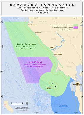
 Map of the Greater Farallones sanctuary | |
| Location | Gulf of the Farallones, California, United States |
| Coordinates | 37°48′N 123°00′W / 37.8°N 123°W |
| Area | 3,295 sq mi (8,530 km2) |
| Established | January 16, 1981[1] |
| Governing body | NOAA National Ocean Service |
| farallones | |

The Greater Farallones National Marine Sanctuary (formerly Gulf of the Farallones National Marine Sanctuary) protects the wildlife, habitats, and cultural resources of one of the most diverse and bountiful marine environments in the world, an area of 3,295 square miles off the northern and central California coast. The waters within Greater Farallones National Marine Sanctuary are part of a nationally significant marine ecosystem, and support an abundance of life, including many threatened or endangered species.[2]
- ^ 46 FR 7942. Retrieved from https://www.govinfo.gov/content/pkg/FR-1981-01-26/pdf/FR-1981-01-26.pdf
- ^ "Greater Farallones National Marine Sanctuary". farallones.noaa.gov. Retrieved 2016-09-16.
