Back غرينديل (ويسكونسن) Arabic Greendale (Wisconsin) Catalan Greendale (lungsod sa Tinipong Bansa, Wisconsin) CEB Greendale (Wisconsin) German Greendale (Wisconsin) Spanish Greendale (Wisconsin) French گریندیل (ويسکانسين) GLK Greendale (Wisconsin) Italian გრინდეილი (მილუოკის ოლქი) Georgian Greendale (Wisconsin) LLD
Greendale | |
|---|---|
 Greendale Village Hall | |
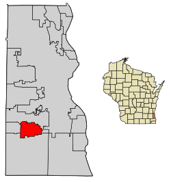
 Location of Greendale in Milwaukee County, Wisconsin. | |
| Coordinates: 42°56′15″N 87°59′49″W / 42.93750°N 87.99694°W | |
| Country | United States |
| State | Wisconsin |
| County | Milwaukee |
| Area | |
| • Total | 5.57 sq mi (14.44 km2) |
| • Land | 5.57 sq mi (14.41 km2) |
| • Water | 0.01 sq mi (0.02 km2) |
| Elevation | 738 ft (225 m) |
| Population | |
| • Total | 14,854 |
| • Estimate (2021)[4] | 14,652 |
| • Density | 2,541.42/sq mi (981.16/km2) |
| Time zone | UTC-6 (Central (CST)) |
| • Summer (DST) | UTC-5 (CDT) |
| ZIP Code | 53129 |
| Area code | 414 |
| FIPS code | 55-31125[5] |
| GNIS feature ID | 1565837[2] |
| Website | www |
Greendale is a village in Milwaukee County, Wisconsin, United States. The population was 14,854 at the 2020 census. Greendale is located southwest of Milwaukee, Wisconsin, and is a part of the Milwaukee metropolitan area. A planned community, it was established by the United States government during the Great Depression.
- ^ "2019 U.S. Gazetteer Files". United States Census Bureau. Retrieved August 7, 2020.
- ^ a b "US Board on Geographic Names". United States Geological Survey. October 25, 2007. Retrieved January 31, 2008.
- ^ Cite error: The named reference
DecennialCensuswas invoked but never defined (see the help page). - ^ Cite error: The named reference
USCensusEst2021CenPopScriptOnlyDirtyFixDoNotUsewas invoked but never defined (see the help page). - ^ "U.S. Census website". United States Census Bureau. Retrieved January 31, 2008.