Back غرينوود (مسيسيبي) Arabic جرينوود (ليفلور) ARZ قرینوود، میسیسیپی AZB Грийнуд (Мисисипи) Bulgarian Greenwood (Mississipi) Catalan Гринвуд (Миссисипи) CE Greenwood (kapital sa kondado sa Tinipong Bansa, Mississippi) CEB Greenwood, Mississippi Welsh Greenwood DAG Greenwood (Mississippi) German
Greenwood, Mississippi | |
|---|---|
 | |
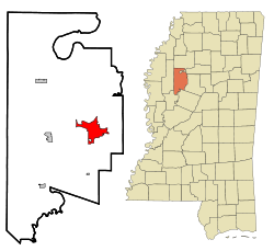
 Location of Greenwood, Mississippi | |
| Coordinates: 33°31′7″N 90°11′2″W / 33.51861°N 90.18389°W | |
| Country | United States |
| State | Mississippi |
| County | Leflore |
| Government | |
| • Mayor | Carolyn McAdams (I) |
| Area | |
| • Total | 12.69 sq mi (302.87 km2) |
| • Land | 12.34 sq mi (301.95 km2) |
| • Water | 0.36 sq mi (0.92 km2) |
| Elevation | 131 ft (40 m) |
| Population (2020) | |
| • Total | 14,490 |
| • Density | 1,174.71/sq mi (453.56/km2) |
| Time zone | UTC−6 (Central (CST)) |
| • Summer (DST) | UTC−5 (CDT) |
| ZIP codes | 38930, 38935 |
| Area code | 662 |
| FIPS code | 28-29340 |
| GNIS feature ID | 0670714 |
| Website | www |
Greenwood is a city in and the county seat of Leflore County, Mississippi, United States,[2] located at the eastern edge of the Mississippi Delta region, approximately 96 miles north of the state capital, Jackson, and 130 miles south of the riverport of Memphis, Tennessee. It was a center of cotton planter culture in the 19th century.
The population was 15,205 at the 2010 census. It is the principal city of the Greenwood Micropolitan Statistical Area. Greenwood developed at the confluence of the Tallahatchie and the Yalobusha rivers, which form the Yazoo River.
- ^ "2020 U.S. Gazetteer Files". United States Census Bureau. Retrieved July 24, 2022.
- ^ "Find a County". National Association of Counties. Archived from the original on May 31, 2011. Retrieved June 7, 2011.


