Back Grimshaw ATJ Grimshaw CEB گریمشا، آلبرتا Persian Grimshaw (Alberta) French Grimshaw Kurdish Гримшо (Алберта) Serbian Grimshaw Swedish Грімшоу Ukrainian Grimshaw (Alberta) Uzbek
Grimshaw | |
|---|---|
Town | |
| Town of Grimshaw | |
 Boundary sign | |
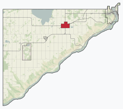
 Location in the MD of Peace No. 136 | |
Location of Grimshaw in Alberta | |
| Coordinates: 56°11′27″N 117°36′42″W / 56.19083°N 117.61167°W | |
| Country | Canada |
| Province | Alberta |
| Region | Northern Alberta |
| Planning region | Upper Peace |
| Municipal district | Municipal District of Peace No. 135 |
| Incorporated[1] | |
| • Village | February 18, 1930 |
| • Town | February 2, 1953 |
| Government | |
| • Mayor | Wendy Wald |
| • Governing body | Grimshaw Town Council |
| Area (2021)[3] | |
| • Land | 7.08 km2 (2.73 sq mi) |
| Elevation | 603 m (1,978 ft) |
| Population | |
| • Total | 2,601 |
| • Density | 367.2/km2 (951/sq mi) |
| Time zone | UTC−7 (MST) |
| • Summer (DST) | UTC−6 (MDT) |
| Highways | Highway 2 Highway 35 |
| Waterway | Lac Cardinal |
| Website | Official website |
Grimshaw is a town in northern Alberta, Canada. It is approximately 25 km (16 mi) west of the Town of Peace River at the junction of Highway 2 and Highway 2A and along Mackenzie Northern Railway. By virtue of being the original starting point of Highway 35, which leads to the Northwest Territories, Grimshaw is referred to as Mile Zero of the Mackenzie Highway.
- ^ "Location and History Profile: Town of Grimshaw" (PDF). Alberta Municipal Affairs. October 7, 2016. p. 288. Retrieved October 13, 2016.
- ^ "Municipal Officials Search". Alberta Municipal Affairs. May 9, 2019. Retrieved October 1, 2021.
- ^ a b Cite error: The named reference
2021censuswas invoked but never defined (see the help page). - ^ "Alberta Private Sewage Systems 2009 Standard of Practice Handbook: Appendix A.3 Alberta Design Data (A.3.A. Alberta Climate Design Data by Town)" (PDF) (PDF). Safety Codes Council. January 2012. pp. 212–215 (PDF pages 226–229). Archived from the original (PDF) on October 16, 2013. Retrieved October 8, 2013.
- ^ "Population and dwelling counts: Canada and population centres". Statistics Canada. February 9, 2022. Retrieved February 13, 2022.

