Back أرخبيل غوايتيكاس Arabic Archipiélagu de les Guaitecas AST Islas Guaitecas CEB Archipiélago de las Guaitecas Spanish Archipel de las Guaitecas French Arcipelago Guaitecas Italian გუაიტეკასის არქიპელაგი Georgian Gvaitekaso salynas Lithuanian Arquipélago das Guaitecas Portuguese Islas Guaitecas Swedish
Native name: Archipiélago de las Guaitecas | |
|---|---|
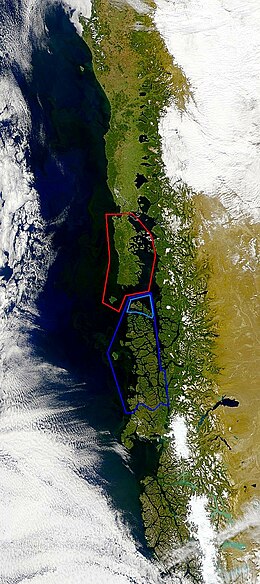
 Guaitecas Archipelago is marked with light blue, Chonos Archipelago with dark blue and Chiloé Archipelago is marked with red. | |
| Geography | |
| Coordinates | 43°55′17″S 73°49′33″W / 43.921322°S 73.825841°W |
| Adjacent to | Open Pacific Ocean, Gulf of Corcovado, Moraleda Channel, Tuamapu Channel, Paso del Chacao |
| Major islands | Gran Guaiteca, Ascención, Betecoy, Clotilde, Leucayec, Elvira, Sánchez, Mulchey |
| Highest elevation | 369 m (1211 ft) |
| Administration | |
| Region | Aisén |
| Province | Aisén |
| Commune | Guaitecas |
| Demographics | |
| Population | 1,843 (2017) |
| Ethnic groups | Chileans, including Chilote-Huilliches. Formerly: Chonos |
| Additional information | |
| NGA UFI=-877176 | |
Guaitecas Archipelago is a sparsely populated archipelago in the Aisén region of Chile. The archipelago is made up of eight main islands and numerous smaller ones. The eight largest islands are from northwest to southeast: Gran Guaiteca, Ascención, Betecoy, Clotilde, Leucayec, Elvira, Sánchez and Mulchey.[1] The islands have subdued topography compared to the Andes, with Gran Guaiteca containing the archipelago's high point at 369 m (1,211 ft).[1]
The main settlement in the archipelago is Melinka, a port town with an economy revolving around fishing and salmon aquaculture. Most islands are forested, rocky with recurrent peat bogs. The archipelago waters are renowned for their rich whale and dolphin fauna. The climate is cool, rainy and oceanic. Historically the islands were inhabited by semi-nomad and seafaring Chonos and lay beyond the southernmost outposts of the Spanish Empire. In the second half of the 19th century, the islands became permanently settled as consequence of a wood logging boom centered on Ciprés de las Guaitecas (Pilgerodendron uviferum), a tree named after the archipelago. Culturally the northwestern part of the archipelago is similar to Chiloé Archipelago.[2]
- ^ a b Cite error: The named reference
primercongresowas invoked but never defined (see the help page). - ^ Saavedra Gallo, Gonzalo (2011). "Tensiones modernizantes y condicionantes culturales del desarrollo en el borde costero del Sur Austral chileno" [Modernizing tensions and cultural conditioners of development in the south austral Chilean coastal seaboard]. Revista Lider (in Spanish). 19: 201–219.