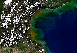
| Gulf of Panama mangroves (NT1414) | |
|---|---|
 Satellite view of Gulf of Parita, fringed by mangroves | |
 Ecoregion territory (in red) | |
| Ecology | |
| Realm | Neotropical |
| Biome | Mangroves |
| Geography | |
| Area | 2,330 km2 (900 sq mi) |
| Countries | |
| Coordinates | 9°00′29″N 79°06′00″W / 9.008°N 79.100°W |
| Designations | |
|---|---|
| Official name | Bahía de Panamá |
| Designated | 20 October 2003 |
| Reference no. | 1319[1] |
The Gulf of Panama mangroves (NT1414) is an ecoregion along the Pacific coast of Panama and Colombia. The mangroves experience seasonal flooding with high levels of sediment, and occasional extreme storms or very low rainfall due to El Niño effects. They are important as a breeding or nursery area for marine species. Areas of the mangroves have been recognized as Important Bird Areas and Ramsar wetlands. The ecoregion has been severely degraded by clearance of mangroves for agriculture, pasturage and shrimp farming, by urban pressure around Panama City, and by pollution related to the Panama Canal.
- ^ "Bahía de Panamá". Ramsar Sites Information Service. Retrieved 25 April 2018.
