Back غوين (ميشيغان) Arabic قویین، میشیقان AZB Gwinn CEB Gwinn (Míchigan) Spanish Gwinn (Michigan) Basque گویین، میشیگان Persian Gwinn (Michigan) LLD Gwinn Dutch Gwinn Polish Gwinn Portuguese
Gwinn, Michigan | |
|---|---|
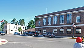
 Street scene in downtown Gwinn | |
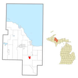
 Location within Marquette County | |
| Coordinates: 46°16′52″N 87°26′27″W / 46.28111°N 87.44083°W | |
| Country | United States |
| State | Michigan |
| County | Marquette |
| Township | Forsyth |
| Founded | 1907 |
| Area | |
| • Total | 2.92 sq mi (7.57 km2) |
| • Land | 2.81 sq mi (7.28 km2) |
| • Water | 0.11 sq mi (0.29 km2) |
| Elevation | 1,099 ft (335 m) |
| Population | |
| • Total | 1,784 |
| • Density | 634.42/sq mi (244.91/km2) |
| Time zone | UTC-5 (Eastern (EST)) |
| • Summer (DST) | UTC-4 (EDT) |
| ZIP Code | 49841 |
| Area code | 906 |
| FIPS code | 26-35760[4] |
| GNIS feature ID | 627559[2] |
Gwinn Model Town Historic District | |
| Location | Including most of the original plat of Gwinn and surrounding greenbelt, Forsyth Township, Michigan |
| Built | 1907 |
| Architect | Warren Manning, D. Fred Charlton |
| Architectural style | Bungalow/Craftsman, Cleveland-Cliff Iron Co. dup |
| NRHP reference No. | 00000286[5] |
| Added to NRHP | June 24, 2002 |
Gwinn is an unincorporated community in Marquette County in the U.S. state of Michigan. It is a census-designated place (CDP) for statistical purposes and has no legal status as an incorporated municipality. The population of the CDP was 1,784 at the 2020 census.[3] The community is located within Forsyth Township.[2]
The CDP includes the nearby communities of Austin to the west and New Swanzy to the east. It is located along M-35 near the forks of the east and middle branches of the Escanaba River. The Gwinn 49841 ZIP Code serves a much larger area, including most of Forsyth Township, as well as portions of Turin Township to the east, Wells and Ewing townships to the south, Tilden Township to the west, and Richmond, Sands, and West Branch townships to the north.[6]
- ^ "2022 U.S. Gazetteer Files: Michigan". United States Census Bureau. Retrieved August 16, 2023.
- ^ a b c U.S. Geological Survey Geographic Names Information System: Gwinn, Michigan
- ^ a b "P1. Race – Gwinn CDP, Michigan: 2020 DEC Redistricting Data (PL 94-171)". U.S. Census Bureau. Retrieved August 16, 2023.
- ^ "U.S. Census website". United States Census Bureau. Retrieved January 31, 2008.
- ^ "National Register Information System". National Register of Historic Places. National Park Service. March 13, 2009.
- ^ "TIGERweb: 49841 5-Digit ZCTA". Geography Division, U.S. Census Bureau. Retrieved August 16, 2023.

