Hakunila
Håkansböle | |
|---|---|
City District | |
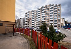
 High rise flats, typical of Hakunila | |
 Location on the map of Vantaa, with the district in red and the major region in light brown | |
| Coordinates: 60°16′43″N 25°06′19″E / 60.27861°N 25.10528°E | |
| Country | |
| City | |
| Major region | Hakunila |
| Area | |
| • Total | 3.0 km2 (1.2 sq mi) |
| • Major region | 36.2 km2 (14.0 sq mi) |
| Population (1.1.2014)[1] | |
| • Total | 11,238 |
| • Density | 3,700/km2 (9,700/sq mi) |
| • Major region | 29,214 |
| • Major region density | 810/km2 (2,100/sq mi) |
| Time zone | GMT +2 |
| Postal Code(s) | 01200, 01201 |
| Website | www |
Hakunila (Finnish: [ˈhɑkunilɑ]; Swedish: Håkansböle, Finland Swedish: [ˈhoːkɑːnsˌbøːle]), is a district and major region of the municipality of Vantaa, Finland, located within the eastern part of the city. The district has a population of 11,238 and a population density of 3,746 inhabitants per square kilometre (9,700/sq mi).
The district is bordered to the west by Lahdenväylä (a constituent of the National road 4 (E75)), to the south by the Ring III (Finnish: Kehä III) beltway, to the east by the districts of Ojanko and Sotunki, and to the north by the district of Itä-Hakkila. Most of central Hakunila was built during the 1970s, and consists of high-rise residential tower blocks.
The Hakunila major region consists of nine districts: the central Hakunila, Itä-Hakkila, Kuninkaanmäki, Länsimäki, Länsisalmi, Ojanko, Rajakylä, Sotunki, and Vaarala. As of January 2014, the Hakunila major region has a total population of 29,214 and a population density of 810 inhabitants per square kilometre (2,100/sq mi).
- ^ Vantaan väestö 2013/2014 (PDF) (Report). Vantaa: City of Vantaa, Tietopalveluyksikkö. 20 August 2014. p. 33. ISBN 978-952-443-480-5. Archived from the original (PDF) on 2 February 2015. Retrieved 15 May 2015.
