Back مقاطعة هيل (ألاباما) Arabic هئیل بؤلگهسی، آلاباما AZB Hale County, Alabama BAR Хейл (окръг, Алабама) Bulgarian হাল কাউন্টি, আলাবামা BPY Hale Gông (Alabama) CDO Хейл (гуо, Алабама) CE Hale County (kondado sa Tinipong Bansa, Alabama) CEB Hale County, Alabama Welsh Hale County (Alabama) German
Hale County | |
|---|---|
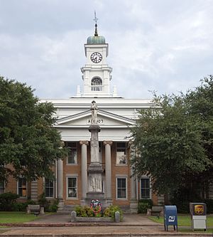
 Hale County Courthouse and Confederate statue in Greensboro | |
 Location within the U.S. state of Alabama | |
 Alabama's location within the U.S. | |
| Coordinates: 32°45′39″N 87°37′47″W / 32.760833333333°N 87.629722222222°W | |
| Country | |
| State | |
| Founded | January 30, 1867 |
| Named for | Stephen F. Hale |
| Seat | Greensboro |
| Largest city | Moundville |
| Area | |
| • Total | 657 sq mi (1,700 km2) |
| • Land | 644 sq mi (1,670 km2) |
| • Water | 13 sq mi (30 km2) 1.9% |
| Population (2020) | |
| • Total | 14,785 |
| • Estimate (2023) | 14,888 |
| • Density | 23/sq mi (8.7/km2) |
| Time zone | UTC−6 (Central) |
| • Summer (DST) | UTC−5 (CDT) |
| Congressional district | 7th |
| Website | www |
| |
Hale County is a county located in the west central portion of the U.S. state of Alabama. As of the 2020 census, the population was 14,785.[1] Its county seat is Greensboro.[2] It is named in honor of Confederate officer Stephen Fowler Hale.[3]
Hale County is part of the Tuscaloosa, AL Metropolitan Statistical Area.
- ^ "State & County QuickFacts". United States Census Bureau. Retrieved September 10, 2023.
- ^ "Find a County". National Association of Counties. Retrieved June 7, 2011.
- ^ Gannett, Henry (1905). The Origin of Certain Place Names in the United States. Govt. Print. Off. pp. 147.