| Halifax River | |
|---|---|
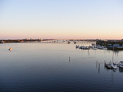
 A view of the Halifax River southbound from the Seabreeze Bridge, Daytona Beach, Volusia County, Florida. Three other bridges can be seen from this vista: Main Street Bridge (closest), Broadway Bridge, and Veterans Memorial Bridge. Two boat marinas can be seen to the right. | |
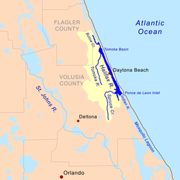
 Halifax River Drainage Basin | |
| Etymology | George Montagu-Dunk, 2nd Earl of Halifax |
| Location | |
| Country | United States |
| State | Florida |
| Cities | Ormond Beach, FL, Holly Hill, FL, Daytona Beach, FL, South Daytona, FL, Port Orange, FL |
| Physical characteristics | |
| Source | Tomoka Basin |
| • location | Tomoka State Park, Volusia County, FL |
| • coordinates | 29°21′40″N 81°05′30″W / 29.36111°N 81.09167°W |
| • elevation | 5 ft (1.5 m) |
| Mouth | Atlantic Ocean |
• location | Ponce Inlet, Volusia County, FL |
• coordinates | 29°04′25″N 80°55′22″W / 29.07361°N 80.92278°W |
• elevation | 0 ft (0 m) |
| Length | 25 mi (40 km) |
| Basin size | 1,009 sq mi (2,610 km2) |
| Discharge | |
| • location | Ponce Inlet, FL |
| Basin features | |
| Tributaries | |
| • left | Halifax Creek |
| • right | Tomoka River, Spruce Creek |
The Halifax River is part of the Atlantic Intracoastal Waterway, located in northeast Volusia County, Florida. The waterway was originally known as the North Mosquito River, but was renamed after George Montagu-Dunk, 2nd Earl of Halifax (for whom Halifax, Nova Scotia, Canada is also named), during the British occupation of Florida (1763–1784).[1][2]
- ^ "Hometown News: East Volusia has rich history". Archived from the original on 2010-06-12. Retrieved 2008-11-19.
- ^ "The Montague Millennium: George Montagu Dunk, 1716-1771". Archived from the original on 2008-12-18. Retrieved 2008-11-20.
{{cite web}}: CS1 maint: unfit URL (link)
