Back هاليدي Arabic هاليدى ARZ هالیدی، قوزئی داکوتا AZB Halliday Catalan Галлидей (Къилбаседа Дакота) CE Halliday CEB Halliday, Gogledd Dakota Welsh Halliday (Dakota del Norte) Spanish Halliday (Ipar Dakota) Basque هالیدی، داکوتای شمالی Persian
Halliday, North Dakota | |
|---|---|
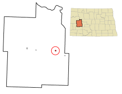
 Location of Halliday, North Dakota | |
| Coordinates: 47°21′08″N 102°20′19″W / 47.35222°N 102.33861°W | |
| Country | United States |
| State | North Dakota |
| County | Dunn |
| Founded | 1914 |
| Area | |
| • Total | 0.47 sq mi (1.21 km2) |
| • Land | 0.46 sq mi (1.19 km2) |
| • Water | 0.01 sq mi (0.01 km2) |
| Elevation | 2,070 ft (631 m) |
| Population | |
| • Total | 241 |
| • Estimate (2022)[4] | 229 |
| • Density | 522.78/sq mi (201.68/km2) |
| Time zone | UTC-7 (Mountain (MST)) |
| • Summer (DST) | UTC-6 (MDT) |
| ZIP code | 58636 |
| Area code | 701 |
| FIPS code | 38-34340 |
| GNIS feature ID | 1036072[2] |
| Website | cityofhalliday.com |
Halliday is a city in Dunn County, North Dakota, United States. The population was 241 at the 2020 census.[3] Halliday was founded in 1914.
Halliday was originally two miles farther north. It moved in 1914 to be near the new Mandan to Killdeer railroad line. In 1900, the first post office was located on William Halliday's place.[5][6]
John S. Lesmeister, who served as the 30th North Dakota State Treasurer, grew up in Halliday.
- ^ "ArcGIS REST Services Directory". United States Census Bureau. Retrieved September 20, 2022.
- ^ a b U.S. Geological Survey Geographic Names Information System: Halliday, North Dakota
- ^ a b "Explore Census Data". United States Census Bureau. Retrieved November 29, 2023.
- ^ Cite error: The named reference
USCensusEst2022was invoked but never defined (see the help page). - ^ North Dakota: Counties - Towns & People, Part III. Watchmaker Publishing, Ltd. 2008. p. 112. ISBN 978-1-60386-342-1.
- ^ Williams, Mary Ann Barnes (1966). Origins of North Dakota Place Names. Bismarck, ND: Bismarck Tribune. p. 98. Retrieved January 4, 2022.