Back Hampshire Afrikaans Hāmtūnesċīr ANG هامبشاير (مقاطعة) Arabic Hampshire AST Hampshire BAN Хэмпшыр Byelorussian Гэмпшыр BE-X-OLD Хампшър Bulgarian Hampshire Breton Hampshire Catalan
Hampshire | |
|---|---|
Spinnaker Tower and Portsmouth Harbour (top), Winchester Cathedral (bottom left), and pannage in the New Forest (bottom right) | |
| Coordinates: 51°03′27″N 1°18′27″W / 51.0575°N 1.3075°W | |
| Sovereign state | United Kingdom |
| Constituent country | England |
| Region | South East |
| Established | Ancient |
| Time zone | UTC+0 (GMT) |
| • Summer (DST) | UTC+1 (BST) |
| UK Parliament | List of MPs |
| Police | Hampshire and Isle of Wight Constabulary |
| Ceremonial county | |
| Lord Lieutenant | Nigel Atkinson |
| High Sheriff | Lady Edwina Grosvenor [1] (2022–23) |
| Area | 3,769 km2 (1,455 sq mi) |
| • Rank | 9th of 48 |
| Population (2022)[2] | 1,877,917 |
| • Rank | 5th of 48 |
| Density | 498/km2 (1,290/sq mi) |
| Non-metropolitan county | |
| County council | Hampshire County Council |
| Control | Conservative |
| Admin HQ | Winchester |
| Area | 3,678 km2 (1,420 sq mi) |
| • Rank | 5th of 21 |
| Population (2022)[3] | 1,416,808 |
| • Rank | 3rd of 21 |
| Density | 385/km2 (1,000/sq mi) |
| ISO 3166-2 | GB-HAM |
| GSS code | E10000014 |
| ITL | UKJ33 |
| Website | hants |
| Unitary authorities | |
| Councils | Southampton Portsmouth |
| Districts | |
 Districts of Hampshire Unitary County council area | |
| Districts | |
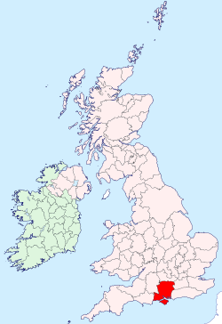
Hampshire (/ˈhæmpʃər/, /-ʃɪər/ ⓘ; abbreviated to Hants.)[a] is a ceremonial county in South East England. It is bordered by Berkshire to the north, Surrey and West Sussex to the east, the Isle of Wight across the Solent to the south, Dorset to the west, and Wiltshire to the north-west. The city of Southampton is the largest settlement.
The county has an area of 3,769 km2 (1,455 sq mi) and a population of 1,844,245, making it the 5th-most populous in England.[4] The South Hampshire built-up area in the south-east of the county has a population of 855,569 and contains the cities of Southampton (269,781) and Portsmouth (208,100). In the north-east, the Farnborough/Aldershot conurbation extends into Berkshire and Surrey and has a population of 252,937. The next-largest settlements are Basingstoke (113,776), Andover (50,887), and Winchester (45,184). The centre and south-west of the county are rural. For local government purposes Hampshire comprises a non-metropolitan county, with eleven districts, and two unitary authority areas: Portsmouth and Southampton. The county historically contained the towns of Bournemouth and Christchurch, which are now part of Dorset, and the Isle of Wight.
Undulating hills characterise much of the county. A belt of chalk crosses the county from north-west, where it forms the Hampshire Downs, to south-east, where it is part of the South Downs. The county's major rivers rise in these hills; the Loddon and Wey drain north, into the Thames, and the Itchen and Test flow south into Southampton Water, a large estuary. In the south-east are Portsmouth Harbour, Langstone Harbour, and the western edge of Chichester Harbour, three large rias. The south-west contains the New Forest, which includes pasture, heath, and forest and is of the largest expanses of ancient woodland remaining in England.
Settled about 14,000 years ago, Hampshire's recorded history dates to Roman Britain, when its chief town was Venta Belgarum (now Winchester). The county was recorded in Domesday Book as divided into 44 hundreds. From the 12th century, the ports settlements grew due to increasing trade with the European mainland resulting from the wool and cloth, fishing, and shipbuilding industries. This meant by the 16th century, Southampton had become more populous than Winchester. In 20th century conflicts, including World War One and Two, Hampshire played a crucial military role due to its ports.
- ^ "No. 63644". The London Gazette. 16 March 2022. p. 5082.
- ^ "Mid-2022 population estimates by Lieutenancy areas (as at 1997) for England and Wales". Office for National Statistics. 24 June 2024. Retrieved 26 June 2024.
- ^ "Mid-Year Population Estimates, UK, June 2022". Office for National Statistics. 26 March 2024. Retrieved 3 May 2024.
- ^ "English Counties by Population and Area 2021/2022 – UK Population Data". populationdata.org.uk. 27 August 2021. Retrieved 15 January 2022.
Cite error: There are <ref group=lower-alpha> tags or {{efn}} templates on this page, but the references will not show without a {{reflist|group=lower-alpha}} template or {{notelist}} template (see the help page).


