Back هاندفورث ARZ Handforth CEB Handforth Welsh Handforth Basque هنفورث Persian Handforth French Handforth LLD Handforth Polish Handforth SIMPLE Handforth Swedish
| Handforth | |
|---|---|
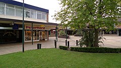
 The Paddock (Handforth Precinct) | |
Location within Cheshire | |
| Population | 9,784 (2021) |
| OS grid reference | SJ8583 |
| Civil parish |
|
| Unitary authority | |
| Ceremonial county | |
| Region | |
| Country | England |
| Sovereign state | United Kingdom |
| Post town | WILMSLOW |
| Postcode district | SK9 |
| Dialling code | 01625 |
| Police | Cheshire |
| Fire | Cheshire |
| Ambulance | North West |
| UK Parliament | |
Handforth is a town and civil parish in Cheshire, England, 9 miles (14 km) south of Manchester city centre.[2] The population at the 2021 census was 9,784.[3] In the 1960s and 1970s, two overspill housing estates, Spath Lane in Handforth,[4] and Colshaw Farm nearby in Wilmslow, were built to re-house people from inner city Manchester.[5] It lies between Wilmslow, Heald Green, Stanley Green and Styal and forms part of the Greater Manchester Built-up Area.
- ^ "Home Page". www.handforth.org.uk.
- ^ "HANDFORTH : latitude, longitude, map and postcode / zip code of Handforth SK9 in United Kingdom". Zip-code.en.mapawi.com. Retrieved 11 August 2014.
- ^ https://citypopulation.de/en/uk/northwestengland/wards/cheshire_east/E05008629__handforth/.
{{cite web}}: Missing or empty|title=(help) - ^ Google Maps: Handforth (Retrieved 29 November 2014)
- ^ Google Maps: Colshaw Farm (Retrieved 29 November 2014)

