Back هارينجفليت Arabic Haringvliet CEB Haringvliet Czech Haringvliet German Haringvliet (brazo de mar) Spanish Haringvliet (bras de mer) French Hjerringfliet Frisian Haringvliet Italian ハーリングフリート川 Japanese ჰარინგვლიტი Georgian
| Designations | |
|---|---|
| Designated | 29 August 2000 |
| Reference no. | 1244[1] |


The Haringvliet is a large inlet of the North Sea, in the province of South Holland in the Netherlands. It is an important estuary of the Rhine-Meuse delta.[2]
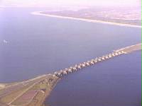
Near Numansdorp, the Hollands Diep splits into the Haringvliet and the Volkerak estuaries. It is closed off near Goedereede from the North Sea by the Haringvlietdam, which provides a road connection between the island of Voorne to the north and the island of Goeree-Overflakkee to the south.[3] The dam with its sluices was built as part of the Delta Works sea barrier protection works.[4]
The Haringvliet estuary contains the island of Tiengemeten, which is separated from the river island of Hoeksche Waard by the Vuile Gat strait.
- ^ "Haringvliet". Ramsar Sites Information Service. Retrieved 25 April 2018.
- ^ "Haringvliet" (in Dutch). Rijkswaterstaat. Archived from the original on 2014-10-26.
- ^ "N57 (Highway)" (in Dutch). Rijkswaterstaat. Archived from the original on 2014-10-26.
- ^ "Haringvlietsluizen" (in Dutch). Rijkswaterstaat.[permanent dead link]