| Harkaway Melbourne, Victoria | |||||||||||||||
|---|---|---|---|---|---|---|---|---|---|---|---|---|---|---|---|
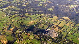
 Aerial view | |||||||||||||||
 | |||||||||||||||
| Coordinates | 37°59′56″S 145°20′38″E / 37.999°S 145.344°E | ||||||||||||||
| Population | 1,011 (2021 census)[1] | ||||||||||||||
| Established | 1860s | ||||||||||||||
| Postcode(s) | 3806 | ||||||||||||||
| Elevation | 167 m (548 ft) | ||||||||||||||
| Location | 39 km (24 mi) from Melbourne | ||||||||||||||
| LGA(s) | City of Casey | ||||||||||||||
| State electorate(s) | |||||||||||||||
| Federal division(s) | |||||||||||||||
| |||||||||||||||
Harkaway is a suburb in Melbourne, Victoria, Australia, 39 km south-east of Melbourne's central business district, located within the City of Casey local government area. Harkaway recorded a population of 1,011 at the 2021 census.[1]
Harkaway is located at the northeast corner of the City of Casey and is bounded by Robinson, Halleur and Harkaway Roads in the west, Boundary Road in the north, Cardinia Creek in the east, and by an irregular border with Berwick, Victoria below Dalton Reserve in the south.[2]
- ^ a b Australian Bureau of Statistics (28 June 2022). "Harkaway (Suburbs and Localities)". 2021 Census QuickStats. Retrieved 10 July 2022.
- ^ Victorian Department of Sustainability and Environment. "Locality Names and Boundaries – City of Casey" (PDF). Archived from the original (PDF) on 19 May 2009. Retrieved 30 October 2008.

