Back Estret d'Haro Catalan Haro Strait (agianan sa Kanada) CEB Haro-Straße German Estrecho de Haro Spanish Détroit de Haro French Stretto di Haro Italian Haro sąsiauris Lithuanian Estreito de Haro Portuguese Haro Strait Swedish Eo biển Haro Vietnamese
| Haro Strait | |
|---|---|
| French: Détroit de Haro | |
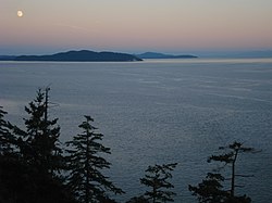
 View of Haro Strait from South Pender Island | |
 Map of Haro Strait and Boundary Pass according to USGS definitions | |
| Location | British Columbia and Washington |
| Coordinates | 48°33′N 123°13′W / 48.550°N 123.217°W |
| Type | Strait |
| Part of | Salish Sea |
| Basin countries | Canada and United States |
| Max. length | 36 km (22 mi) |
| Max. width | 19 km (12 mi) |
| Settlements | Victoria, Saanich, Sidney |
The Haro Strait is one of the main channels connecting the Strait of Georgia to the Strait of Juan de Fuca, separating Vancouver Island and the Gulf Islands in British Columbia, Canada from the San Juan Islands of Washington state in the United States.
The strait is a critical part of the international boundary between Canada and the United States. It stretches from the western terminus of the 49th parallel segment of that boundary, and was chosen by the arbitrator in the San Juan Islands dispute (Pig War) over the Rosario Strait.
