Back هاربسدن Arabic هاربسدن ARZ Harpsden CEB Harpsden French Harpsden LLD Harpsden Dutch Harpsden Polish Harpsden Swedish Harpsden Turkish Harpsden ZH-MIN-NAN
| Harpsden | |
|---|---|
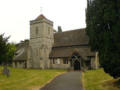
 Parish Church of Saint Margaret | |
Location within Oxfordshire | |
| Area | 8.77 km2 (3.39 sq mi) |
| Population | 560 (2001 census)[1] |
| • Density | 64/km2 (170/sq mi) |
| OS grid reference | SU7680 |
| • London | 34 miles (55 km) |
| Civil parish |
|
| District | |
| Shire county | |
| Region | |
| Country | England |
| Sovereign state | United Kingdom |
| Post town | Henley-on-Thames |
| Postcode district | RG9 |
| Dialling code | 01491 |
| Police | Thames Valley |
| Fire | Oxfordshire |
| Ambulance | South Central |
| UK Parliament | |
Harpsden is a rural and semi-rural village and civil parish immediately south of Henley-on-Thames in South Oxfordshire, Oxfordshire, England. Its scattered centre is set 0.5 miles (0.80 km) from the east border which is the River Thames, marking a short boundary with Berkshire. The parish extends 5 miles (8.0 km) inland and borders Rotherfield Peppard to the west, that is, next to its main sections of woodland in the southern extreme of the Chiltern Hills including an SSSI area of ancient woodland. The village has neither a railway station nor shops, but has the main road from Reading to Henley, both of which have grown substantially since World War II into centres of trade, education and general meeting places, such as by their increased number of cafés and restaurants.
- ^ "Area: Harpsden CP (Parish): Parish Headcounts". Neighbourhood Statistics. Office for National Statistics. Archived from the original on 22 June 2011. Retrieved 17 March 2010.
