Haruru | |
|---|---|
 Haruru Falls | |
 | |
| Coordinates: 35°16′52″S 174°03′29″E / 35.281°S 174.058°E | |
| Country | New Zealand |
| Region | Northland Region |
| District | Far North District |
| Ward | Bay of Islands-Whangaroa |
| Community | Bay of Islands-Whangaroa |
| Subdivision | Paihia |
| Electorates | |
| Government | |
| • Territorial Authority | Far North District Council |
| • Regional council | Northland Regional Council |
| Area | |
| • Total | 1.53 km2 (0.59 sq mi) |
| Population (June 2023)[2] | |
| • Total | 1,210 |
| • Density | 790/km2 (2,000/sq mi) |
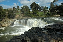
Haruru is a residential and commercial locality in the Far North District of New Zealand. State Highway 11 runs through the locality. Puketona is 10 kilometres west, and Paihia is 4 kilometres east, The name means a continuous noise or roar in the Māori language,[3] which refers to the sound of Haruru Falls, a five metre high broad waterfall about a kilometre away.[4]
- ^ Cite error: The named reference
Areawas invoked but never defined (see the help page). - ^ "Subnational population estimates (RC, SA2), by age and sex, at 30 June 1996-2023 (2023 boundaries)". Statistics New Zealand. Retrieved 25 October 2023. (regional councils); "Subnational population estimates (TA, SA2), by age and sex, at 30 June 1996-2023 (2023 boundaries)". Statistics New Zealand. Retrieved 25 October 2023. (territorial authorities); "Subnational population estimates (urban rural), by age and sex, at 30 June 1996-2023 (2023 boundaries)". Statistics New Zealand. Retrieved 25 October 2023. (urban areas)
- ^ "haruru". Māori dictionary. Retrieved 6 May 2020.
- ^ Hyde, Chris (3 September 2017). "World famous in NZ: Haruru Falls, Bay of Islands". Stuff.
