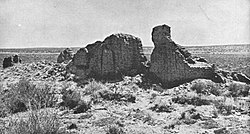
Hawikuh | |
 Ruins of Mission La Purísima Concepción de Hawikuh, photo circa 1886 | |
| Nearest city | Zuni, New Mexico |
|---|---|
| Coordinates | 34°55′56″N 108°59′4.4″W / 34.93222°N 108.984556°W |
| Area | 10 acres (4.0 ha) |
| Built | 1539 |
| Part of | Zuni-Cibola Complex (ID74002267) |
| NRHP reference No. | 66000502[1] |
| Significant dates | |
| Added to NRHP | October 15, 1966 |
| Designated NHL | October 9, 1960[2] |
| Designated NHLDCP | December 2, 1974 |
Hawikuh (also spelled Hawikku, meaning "gum leaves" in Zuni[3]), was one of the largest of the Zuni pueblos at the time of the Spanish entrada. It was founded around 1400 AD.[3] It was the first pueblo to be visited and conquered by Spanish explorers. The Spanish chroniclers referred to it as Cevola, Tzibola, or Cibola.
The pueblo site is located 12 miles (19 km) southwest of Zuni Pueblo, on the Zuni Indian Reservation in Cibola County, New Mexico. In 1960 the site was designated as a National Historic Landmark known as the Hawikuh Ruins. It is included as a contributing part of the Zuni-Cibola Complex of archaeological sites, a larger National Historic Landmark District designated by the United States Department of Interior in 1974.
- ^ "National Register Information System". National Register of Historic Places. National Park Service. July 9, 2010.
- ^ "National Historic Landmarks Survey, New Mexico" (PDF). National Park Service. Retrieved December 17, 2016.
- ^ a b Lanmon, Dwight P. and Harlow, Francis, "A brief history of the Ashiwi (Zuni) pueblos", in The Pottery of Zuni Pueblo, 2008, Museum of New Mexico Press. ISBN 0-89013-508-8


