Back Hawker (lungsod sa Ostralya) CEB هاوکر (استرالیای جنوبی) Persian Hawker (Australia Południowa) Polish Hawker, South Australia SIMPLE Hawker, South Australia Swedish
| Hawker South Australia | |||||||||||||||
|---|---|---|---|---|---|---|---|---|---|---|---|---|---|---|---|
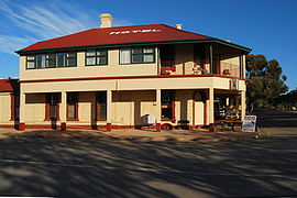
 Hawker Hotel-Motel | |||||||||||||||
| Coordinates | 31°53′28″S 138°25′20″E / 31.891074°S 138.422137°E[1] | ||||||||||||||
| Population | 226 (UCL 2021)[2] | ||||||||||||||
| Established | 1 July 1880 (town) 25 November 1999 (locality)[3][4] | ||||||||||||||
| Postcode(s) | 5434 | ||||||||||||||
| Elevation | 315 m (1,033 ft)[5] | ||||||||||||||
| Location | 365 km (227 mi) N of Adelaide | ||||||||||||||
| LGA(s) | Flinders Ranges Council | ||||||||||||||
| Region | Far North[1] | ||||||||||||||
| County | Blachford Hanson[1] | ||||||||||||||
| State electorate(s) | Stuart | ||||||||||||||
| Federal division(s) | Grey | ||||||||||||||
| |||||||||||||||
| |||||||||||||||
| Footnotes | Adjoining localities[1] | ||||||||||||||
Hawker is a town and a locality in the Flinders Ranges area of South Australia, 365 kilometres (227 mi) north of Adelaide. It is in the Flinders Ranges Council, the state Electoral district of Stuart and the federal Division of Grey.
- ^ a b c d "Search results for 'Hawker, LOCB' with the following datasets selected – 'Suburbs and Localities', 'Counties', 'Hundreds', 'Government Towns' 'Local Government Areas', 'SA Government Regions' and 'Gazetteer'". Location SA Map Viewer. South Australian Government. Retrieved 27 January 2018.
- ^ Australian Bureau of Statistics (28 June 2022). "Hawker (urban centre and locality)". Australian Census 2021.
- ^ Morgan, William (1 July 1880). "Untitled proclamation re the "Town of Hawker"" (PDF). The South Australian Government Gazette. Government of South Australia. p. 8. Retrieved 31 December 2018.
- ^ "GEOGRAPHICAL NAMES ACT 1991 Notice to Assign Boundaries and Names to Places" (PDF), The South Australian Government Gazette: 2442, 25 November 1999, retrieved 27 January 2018
- ^ a b c d "Climate statistics for HAWKER". Bureau of Meteorology. Retrieved 21 January 2014.
