Hell Gates

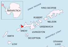
Location of Byers Peninsula on Livingston Island in the South Shetland Islands
Devils Point from Lucifer Crags, with Hell Gates and Vardim Rocks in the middle ground, Long Rock in Morton Strait and Snow Island in the background, and Smith Island seen on the horizon on the right
Topographic map of Livingston Island, Greenwich, Robert, Snow and Smith Islands

Hell Gates (62°40′20.3″S 61°10′46.4″W / 62.672306°S 61.179556°W / -62.672306; -61.179556) is a narrow (20 m wide) boat passage between the Vardim Rocks and Devils Point on Byers Peninsula, connecting Raskuporis Cove and Osogovo Bay at the southwest end of Livingston Island in the South Shetland Islands, Antarctica. The name dates back to about 1821 and was applied by early sealers in the area because many lives and ships were lost here.[1]

  1. ^ Cite error: The named reference gnis was invoked but never defined (see the help page).

From Wikipedia, the free encyclopedia · View on Wikipedia

Developed by razib.in