Back مقاطعة هينديرسون (كنتاكي) Arabic Henderson County, Kentucky BAR Хендерсън (окръг, Кентъки) Bulgarian হেন্ডারসন কাউন্টি, কেন্টাকি BPY Henderson Gông (Kentucky) CDO Хендерсон (гуо, Кентукки) CE Henderson County (kondado sa Tinipong Bansa, Kentucky) CEB Henderson County, Kentucky Welsh Henderson County (Kentucky) German Κομητεία Χέντερσον (Κεντάκι) Greek
Henderson County | |
|---|---|
 Henderson County courthouse in Henderson, Kentucky | |
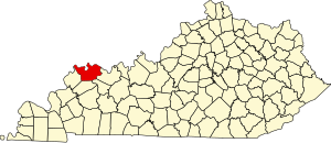
 Location within the U.S. state of Kentucky | |
 Kentucky's location within the U.S. | |
| Coordinates: 37°48′N 87°34′W / 37.8°N 87.57°W | |
| Country | |
| State | |
| Founded | 1798 |
| Named for | Richard Henderson |
| Seat | Henderson |
| Largest city | Henderson |
| Area | |
| • Total | 466 sq mi (1,210 km2) |
| • Land | 437 sq mi (1,130 km2) |
| • Water | 30 sq mi (80 km2) 6.4% |
| Population (2020) | |
| • Total | 44,793 |
| • Estimate (2023) | 44,119 |
| • Density | 96/sq mi (37/km2) |
| Time zone | UTC−6 (Central) |
| • Summer (DST) | UTC−5 (CDT) |
| Congressional district | 1st |
| Website | hendersonky |
Henderson County is a county in the U.S. state of Kentucky. The county is located in western Kentucky on the Ohio River across from Evansville, Indiana. As of the 2020 census, the population was 44,793.[1] Its county seat is Henderson.[2]
The county was formed in 1798[3] and named for Richard Henderson[4] who purchased 17,000,000 acres (69,000 km2) of land from the Cherokee, part of which would later make up the county.
Henderson County lies within the West Kentucky Coal Field area. It is also part of the Evansville, IN-KY Metropolitan Statistical Area.
- ^ "State & County QuickFacts". United States Census Bureau. Retrieved July 6, 2022.
- ^ "Find a County". National Association of Counties. Archived from the original on May 31, 2011. Retrieved June 7, 2011.
- ^ "Henderson County". The Kentucky Encyclopedia. 2000. Archived from the original on September 4, 2015. Retrieved August 22, 2014.
- ^ The Register of the Kentucky State Historical Society, Volume 1. Kentucky State Historical Society. 1903. pp. 35.