Back Hengelo, Overijssel Afrikaans هينجيلو Arabic ܗܢܓܠܘ ARC Хенгело Bulgarian Hengelo Catalan Gemeente Hengelo CEB Hengelo Czech Hengelo Danish Hengelo German Hengelo Esperanto
Hengelo
Hengel (Twents) | |
|---|---|
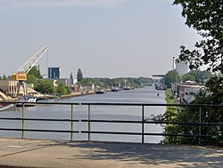
 Twentekanaal through Hengelo | |
 Location in Overijssel | |
| Coordinates: 52°15′55″N 6°47′35″E / 52.26528°N 6.79306°E | |
| Country | Netherlands |
| Province | Overijssel |
| Government | |
| • Body | Municipal council |
| • Mayor | Sander Schelberg (VVD) |
| Area | |
| • Total | 61.83 km2 (23.87 sq mi) |
| • Land | 60.84 km2 (23.49 sq mi) |
| • Water | 0.99 km2 (0.38 sq mi) |
| Elevation | 18 m (59 ft) |
| Population (2023)[4] | |
| • Total | 82,311 |
| • Density | 1,332/km2 (3,450/sq mi) |
| Demonym | Hengolian |
| Time zone | UTC+1 (CET) |
| • Summer (DST) | UTC+2 (CEST) |
| Postcode | 7550–7559 |
| Area code | 074 |
| Climate | Cfb |
| Website | www |


Hengelo (Dutch: [ˈɦɛŋəloː] ; Tweants: Hengel) is a city in the eastern part of the Netherlands, in the Twente region, in the province of Overijssel. It is part of a larger urban area that also includes Enschede, Borne, Almelo and Oldenzaal.
Due to its geomorphology, being situated relatively low in the landscape, Hengelo is a place where streams converge. By consequence, it became a crossroad, inhabited early on in history, which has made it into an infrastructural hub and an industrial centre today. For the 19th century industry, water was needed for bleaching textile, while factories also needed water for their steam engines, and for cooling. Over time, Hengelo became known as metaalstad, for its machine factories and electrical engineering companies. In addition, salt mining developed into an important industry too, which also led to the production of chemical derivatives.
Due to its strategical importance, Hengelo was bombed during World War II. Afterwards, a reconstruction plan was developed that made it into a modern city, partly at the cost of still remaining historical structures. Well-known Dutch planners and architects have left their traces inside and outside the city. Among their most notable efforts are several residential areas, being inspired by the principles of the garden city movement. Due to the vicinity of University of Twente and ArtEZ University of Arts, in Enschede, many students and graduates have come to live and work in Hengelo. Besides economic growth, this has also contributed to the city's development in regard to arts and culture.
- ^ "drs. Schelberg, Sander W.J.G" (in Dutch). Gemeente Hengelo. Retrieved 28 June 2024.
- ^ "Kerncijfers wijken en buurten 2020" [Key figures for neighbourhoods 2020]. StatLine (in Dutch). CBS. 24 July 2020. Retrieved 19 September 2020.
- ^ "Postcodetool for 7551EC". Actueel Hoogtebestand Nederland (in Dutch). Het Waterschapshuis. Retrieved 29 March 2014.
- ^ "Bevolkingsontwikkeling; regio per maand" [Population growth; regions per month]. CBS Statline (in Dutch). CBS. 1 January 2021. Retrieved 2 January 2022.


