Back Henri Pittier National Park CEB Nationalpark Henri Pittier German Nacia Parko Henri Pittier Esperanto Parque nacional Henri Pittier Spanish Henri-Pittier Parke Nazionala Basque پارک ملی انری پیتیر Persian Parc national Henri Pittier French Henri Pittier Nemzeti Park Hungarian Parco nazionale Henri Pittier Italian ანრი-პიტიეს ეროვნული პარკი Georgian
| Henri Pittier National Park | |
|---|---|
 | |
| Nearest city | Maracay |
| Coordinates | 10°22′48″N 67°37′08″W / 10.380°N 67.619°W |
| Area | 1078 km2 |
| Established | 13 February 1937 |
| Governing body | INPARQUES |
| www | |
Henri Pittier National Park is the oldest national park in Venezuela, originally created in 1937 under the name of Rancho Grande by decree of President Eleazar López Contreras. In 1953 the park was renamed in honor of Henri Pittier, a distinguished Swiss geographer, botanist and ethnologist, who arrived in Venezuela in 1917, classified more than 30,000 plants in the country and devoted many years studying the flora and fauna in the park.
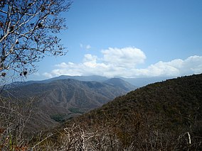
Henri Pittier National Park has the honor of having started the history of national parks of Venezuela. Its 107,800 hectares, located in the north of Aragua state, comprise most of the Araguan coast and mountainous area of Carabobo state. It also borders San Esteban National Park. Henri Pittier National Park is the largest among the national parks of the Venezuelan Coastal Range.
The park consists of two geographic systems: a steep mountainous interior where there are more than 500 bird species and 22 endemic species and a coastal area with bays, beaches and resorts with huge tourism potential. There is a great diversity of flora and fauna. The park is an Important Bird Area.[1] and is an Alliance for Zero Extinction (AZE) site.
With its nine major rivers, the park is an important source of water for surrounding cities and towns. It also contains land where some of the most highly-acclaimed cacao in the world is cultivated, especially in the village of Chuao.
- ^ BirdLife International (2015) Bird Areas factsheet: Henri Pittier National Park (Parque Nacional Henri Pittier IBA) Downloaded from http://www.birdlife.org on 25/08/2015
