Back Heraldeiland Afrikaans Islla Herald AST Herald adası Azerbaijani Геральд Byelorussian Геральд (востраў) BE-X-OLD Хералд (остров) Bulgarian Illa de Herald (Àrtic) Catalan Ostrov Geral'd CEB Herald-Insel German Isla Herald Spanish
Russian: Остров Геральд | |
|---|---|
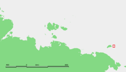
 Herald Island map | |
 Location of Herald Island; the larger island just to the west is Wrangel Island. | |
| Geography | |
| Area | 11.3 km2 (4.4 sq mi) |
| Highest elevation | 364 m (1194 ft) |
| Administration | |
| Demographics | |
| Population | 0 |
Herald Island (Russian: Остров Геральд, Ostrov Gerald) is a small, isolated Russian island in the Chukchi Sea, 60 kilometres (30 nautical miles) east of Waring Point, Wrangel Island. It rises in sheer cliffs, making it quite inaccessible, either by ship or by plane. The only bit of accessible shoreline is at its northwestern point, where the cliffs have crumbled into piles of loose rocks and gravel. Its area is 11.3 km2 (4+3⁄8 sq mi) and the maximum height above sea level is 364 m (1,194 ft). The island is unglaciated and uninhabited. It is the northeasternmost point of land in the world.
Herald Island belongs administratively to the Chukotka Autonomous Okrug of the Russian Federation. Along with Wrangel Island, Herald Island has been part of the Wrangel Island Wildlife Preserve, a Russian National Park, since 1976. Cape Dmitrieva on Herald Island, marks the easternmost limits of the nature reserve.
Herald Island is named after survey vessel HMS Herald, from which the island was discovered in 1849.
