| Hindu Kush alpine meadow | |
|---|---|
 | |
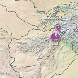
 Ecoregion territory (in purple) | |
| Ecology | |
| Realm | Palearctic |
| Biome | Montane grasslands and shrublands |
| Geography | |
| Area | 28,326 km2 (10,937 sq mi) |
| Country | Afghanistan |
| Coordinates | 35°45′N 70°45′E / 35.75°N 70.75°E |
The Hindu Kush alpine meadow ecoregion (WWF ID: PA1005) covers a portion of the Hindu Kush Mountain Range in northern Afghanistan. Most of the terrain is between 3,000 and 4,000 meters in elevation. This portion of the Hindu Kush is very mountainous, with steep slopes. About half of the alpine meadow is bare rock or gravely soils with sparse vegetation. The remainder supports herbaceous cover of grasses and cushion plants. Human habitation is scarce and follows the river courses in the valleys.[1][2][3][4]
- ^ "Hindu Kush alpine meadow". World Wildlife Federation. Retrieved March 21, 2020.
- ^ "Map of Ecoregions 2017". Resolve, using WWF data. Retrieved September 14, 2019.
- ^ "Hindu Kush alpine meadow". Digital Observatory for Protected Areas. Retrieved August 1, 2020.
- ^ "Hindu Kush alpine meadow". The Encyclopedia of Earth. Retrieved August 28, 2020.
