Back Hinterrhein ALS هينترهين ARZ Hinterrhein (suba) CEB Hinterrhein German Rin posterior Spanish هینترراین Persian Hinterrhein Finnish Rhin postérieur French Reno Posteriore Italian 힌터라인강 Korean
This article needs additional citations for verification. (June 2008) |
| Hinterrhein Posterior Rhine | |
|---|---|
 The Hinterrhein southwest of Splügen | |
 | |
| Native name |
|
| Location | |
| Country | Switzerland |
| Canton | Grisons |
| Physical characteristics | |
| Source | |
| • coordinates | 46°29′55″N 9°3′45″E / 46.49861°N 9.06250°E |
| • elevation | 2,400 m (7,900 ft) |
| Mouth | |
• coordinates | 46°49′24″N 9°24′28″E / 46.82333°N 9.40778°E |
• elevation | 585 m (1,919 ft) |
| Length | 64 km (40 mi) |
| Basin size | 1,693 km2 (654 sq mi) |
| Discharge | |
| • average | 59.6 m3/s (2,100 cu ft/s)[1] |
| Basin features | |
| Progression | Rhine→ North Sea |
| River system | Rhine |
| Tributaries | |
| • right | Ragn da Ferrera, Albula/Alvra |
| Waterbodies | Sufner See |
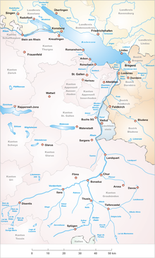
The Hinterrhein (German: [ˈhɪntɐˌʁaɪn] ; Sutsilvan: Ragn Posteriur; Sursilvan: Rein Posteriur; Rumantsch Grischun, Vallader, and Puter: Rain Posteriur; Surmiran: Ragn posteriour; Italian: Reno Posteriore), or Posterior Rhine, is the right of the two initial tributaries of the Rhine (the other being the Vorderrhein). It is located in the canton of Grisons (Graubünden), Switzerland. One of its upper tributaries is Reno di Lei, which is the outflow of Lago di Lei located in Lombardy, Italy.
Although it is shorter in length, its volume is larger than that of the Vorderrhein at their confluence near Reichenau, after which the river is called the Alpine Rhine, which flows out into Lake Constance (Bodensee).