| Hiwassee Dam | |
|---|---|
 | |
| Official name | Hiwassee Dam |
| Location | Cherokee County, North Carolina, United States |
| Coordinates | 35°9′5″N 84°10′39″W / 35.15139°N 84.17750°W |
| Construction began | July 15, 1936 |
| Opening date | February 8, 1940 |
| Operator(s) | Tennessee Valley Authority |
| Dam and spillways | |
| Impounds | Hiwassee River |
| Height | 307 ft (94 m) |
| Length | 1,376 ft (419 m) |
| Reservoir | |
| Creates | Hiwassee Reservoir |
| Total capacity | 434,000 acre⋅ft (535,000 dam3) |
| Catchment area | 968 sq mi (2,510 km2) |
| Power Station | |
| Installed capacity | 185 MW |
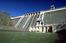
Hiwassee Dam is a hydroelectric dam on the Hiwassee River in Cherokee County, in the U.S. state of North Carolina. It is one of three dams on the river owned and operated by the Tennessee Valley Authority, which built the dam in the late 1930s to bring flood control and electricity to the region.[1] The dam impounds the Hiwassee Lake of 6,000 acres (2,400 ha), and its tailwaters are part of Apalachia Lake. At 307 feet (94 m), Hiwassee Dam is the highest overspill dam east of the Mississippi River and is second only to Grand Coulee dam in the nation.[2] At the time it was completed, it was the highest overspill dam in the world.[3][4]
Hiwassee Dam is the third highest dam in the TVA system, behind only Fontana and Watauga.[5] The dam and associated infrastructure was listed on the National Register of Historic Places in 2017.[6]
Hiwassee Dam is named after the Hiwassee River.[1] The river's name is derived from the Cherokee word for savanna, or large meadow. Two of the tribe's towns along the river in the 18th century were also called Hiwassee.[7]
- ^ a b Tennessee Valley Authority, The Hiwassee Project: A Comprehensive Report on the Planning, Design, Construction, and Initial Operations of the Hiwassee Project (Hiwassee Valley Projects Volume 1), Technical Report No. 5 (Washington, D.C.: U.S. Government Printing Office, 1946), pp. 1-8, 39-40, 211, 230, 242, 248.
- ^ "Hiwassee Dam (Q-54) | NC DNCR". www.dncr.nc.gov. 2024-01-23. Retrieved 2024-04-14.
- ^ "Hiawassee Dam". North Carolina Highway Historical Marker Program. North Carolina Department of Cultural Resources. Retrieved 2023-08-06.
- ^ McKeever, Mrs. Hobart (1961-01-29). "Cherokee County Shows Greatest Progress During 1950-60 Decade". Asheville Citizen-Times. p. 77. Retrieved 2024-03-21.
- ^ Tennessee Valley Authority, The Nickajack Project: A Report on the Planning, Design, Construction, Initial Operations, and Costs, Technical Report No. 16 (Knoxville, Tenn.: Tennessee Valley Authority, 1972), pp. 10-11.
- ^ "National Register Database and Research - National Register of Historic Places (U.S. National Park Service)". www.nps.gov. Retrieved 2024-03-15.
- ^ James Mooney, Myths of the Cherokee and Sacred Formulas of the Cherokee (Nashville, Tenn.: C and R Elder, 1972), p. 512.
