Back Hogsback Afrikaans Hogsback (Südafrika) German Hogsback Estonian Hogsback Italian Hogsback Dutch Hogsback, Kapa Bohlabela NSO Хогсбэк (ЮАР) Russian Hogsback, Kapa Botjhabela Sesotho IHogsback, IMpumalanga Kapa Zulu
Hogsback | |
|---|---|
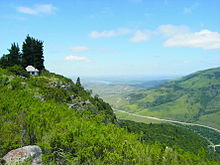
Clockwise from Top: Hills near Hogsback, Snow in Hogsback, the Hogsback Pass, Menziesberg, lake in Hogsback. | |
| Nickname: "Where the fairies live" | |
| Coordinates: 32°35′53″S 26°56′17″E / 32.598°S 26.938°E | |
| Country | South Africa |
| Province | Eastern Cape |
| District | Amathole |
| Municipality | Raymond Mhlaba |
| Area | |
| • Total | 13.78 km2 (5.32 sq mi) |
| Population (2011)[1] | |
| • Total | 1,029 |
| • Density | 75/km2 (190/sq mi) |
| Racial makeup (2011) | |
| • Black African | 65.7% |
| • Coloured | 2.2% |
| • Indian/Asian | 0.5% |
| • White | 30.5% |
| • Other | 1.1% |
| First languages (2011) | |
| • Xhosa | 63.5% |
| • English | 27.7% |
| • Afrikaans | 6.0% |
| • Other | 2.9% |
| Time zone | UTC+2 (SAST) |
| PO box | 5721 |
| Area code | 045 |
| Website | http://www.hogsback.com/ |


Hogsback is a village in the Amathole Mountains in the Eastern Cape Province, South Africa.
- ^ a b c d "Main Place Hogsback". Census 2011.


