Back Hopetoun (lungsod sa Ostralya, State of Victoria) CEB هوپتون، ویکتوریا Persian Hopetoun French Hopetoun (Victoria) Italian Hopetoun (Victoria) Dutch Hopetoun (Wiktoria) Polish Hopetoun Portuguese Хоптен Russian Hopetoun (ort i Australien, Victoria) Swedish Гоптон Ukrainian
| Hopetoun Victoria | |
|---|---|
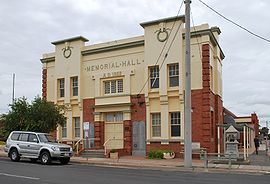
 Memorial Hall in Hopetoun, built in 1922 | |
| Coordinates | 35°43′S 142°21′E / 35.717°S 142.350°E |
| Population | 739 (2016 census)[1] |
| Postcode(s) | 3396 |
| Location |
|
| LGA(s) | Shire of Yarriambiack |
| State electorate(s) | Mildura |
| Federal division(s) | Mallee |
Hopetoun is a town which serves as the major service centre for the Southern Mallee area of Victoria, Australia.[2] Hopetoun is situated 400 km (249 mi) north-west of Melbourne on the Henty Highway in the Shire of Yarriambiack. In the 2016 census, Hopetoun had a population of 739.[1]
- ^ a b Australian Bureau of Statistics (27 June 2017). "Hopetoun (State Suburb)". 2016 Census QuickStats. Retrieved 28 January 2018.
- ^ Brocklebank, Deirdre Heather (2010), Tell tales : memoirs of Hopetoun Victoria 1950s-70 ([Revised edition] ed.), Deirdre Brocklebank, ISBN 978-0-646-54885-2
