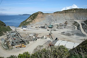
Horokiwi | |
|---|---|
 Horokiwi Quarry | |
 | |
| Coordinates: 41°12′25″S 174°50′56″E / 41.207°S 174.849°E | |
| Country | New Zealand |
| City | Wellington |
| Local authority | Wellington City Council |
| Electoral ward |
|
| Area | |
| • Land | 733 ha (1,811 acres) |
| Population (2018)[1] | |
| • Total | 183 |
| Takapu Valley | ||
| Grenada North, Woodridge, Newlands |
|
Lower Hutt |
| Wellington Harbour |
Horokiwi is an outer northern suburb of Wellington.[2] The area is semi-rural and there are no schools; most children attend schools in nearby Lower Hutt, and Primary School zoning is for Korokoro. The only feature other than houses and farms is Horokiwi Quarry.
- ^ Cite error: The named reference
Census 2018was invoked but never defined (see the help page). - ^ "Wellington City Suburbs" (PDF). Wellington City Council. Retrieved 4 December 2013.
