Back Hoylake CEB Hoylake Welsh Hoylake German Hoylake Spanish Hoylake Basque هویلیک Persian Hoylake French Hoylake Italian Hoylake Dutch Hoylake NN
| Hoylake | |
|---|---|
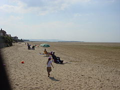
 Hoylake beach, looking towards Hilbre Island | |
Location within Merseyside | |
| Population | 5,710 (2001 census) |
| OS grid reference | SJ215888 |
| • London | 183 mi (295 km)[1] SE |
| Metropolitan borough | |
| Metropolitan county | |
| Region | |
| Country | England |
| Sovereign state | United Kingdom |
| Post town | WIRRAL |
| Postcode district | CH47, CH48 |
| Dialling code | 0151 |
| ISO 3166 code | GB-WRL |
| Police | Merseyside |
| Fire | Merseyside |
| Ambulance | North West |
| UK Parliament | |
Hoylake (/hɔɪˈleɪk/) is a seaside town in the Metropolitan Borough of Wirral, Merseyside, England. It is at the north west of the Wirral Peninsula, near West Kirby and where the River Dee meets the Irish Sea.[2]
At the 2001 census, the population of Hoylake was 5,710,[3] while the overall population of the local government ward of Hoylake and Meols was 13,042[4] (rising to 13,348 in 2011[5]).
In the nineteenth century, the town grew up around the small fishing village of Hoose (lit. 'hollows'), a settlement that was recorded in the Domesday Book of 1086 within the Hundred of 'Wilaveston' (historically part of Cheshire). The town takes its name from 'Hoyle Lake', a nearby channel of water out towards Hilbre Island that provided a safe anchorage for shipping.
- ^ "Coordinate Distance Calculator". boulter.com. Retrieved 6 March 2016.
- ^ "Hoylake Tourist Information & Visitor Guide". www.visitwirral.com. Wirral Council. Retrieved 29 May 2017.
- ^ "Wirral 2001 Census: Hoylake". Metropolitan Borough of Wirral. Retrieved 23 December 2007. [dead link]
- ^ "2001 Census: Hoylake & Meols Ward". Office for National Statistics. Retrieved 20 February 2007.
- ^ UK Census (2011). "Local Area Report – Hoylake and Meols Ward (E05000963)". Nomis. Office for National Statistics. Retrieved 17 August 2020.
