Back Huangpi (kapital sa gatos sa Pangmasang Republika sa Tśina) CEB Huangpi German Huangpi Spanish Huangpi Barrutia Basque District de Huangpi French Vòng-pî-khî HAK Distrik Huangpi ID Distretto di Huangpi Italian 黄陂区 Japanese 황피구 Korean
Huangpi
黄陂区 | ||||||||||||||||||||||||||||||||||||
|---|---|---|---|---|---|---|---|---|---|---|---|---|---|---|---|---|---|---|---|---|---|---|---|---|---|---|---|---|---|---|---|---|---|---|---|---|
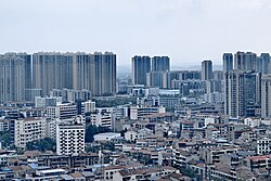
 Huangpi Skyline | ||||||||||||||||||||||||||||||||||||
 | ||||||||||||||||||||||||||||||||||||
| Coordinates: 30°52′30″N 114°22′30″E / 30.8750°N 114.3750°E[1] | ||||||||||||||||||||||||||||||||||||
| Country | People's Republic of China | |||||||||||||||||||||||||||||||||||
| Province | Hubei | |||||||||||||||||||||||||||||||||||
| Sub-provincial city | Wuhan | |||||||||||||||||||||||||||||||||||
| Area | ||||||||||||||||||||||||||||||||||||
| • Total | 2,261.00 km2 (872.98 sq mi) | |||||||||||||||||||||||||||||||||||
| Population (2010)[3] | ||||||||||||||||||||||||||||||||||||
| • Total | 874,938 | |||||||||||||||||||||||||||||||||||
| • Density | 387/km2 (1,000/sq mi) | |||||||||||||||||||||||||||||||||||
| Time zone | UTC+8 (China Standard) | |||||||||||||||||||||||||||||||||||
| Postal code | 4303XX | |||||||||||||||||||||||||||||||||||
| Wuhan district map |
| |||||||||||||||||||||||||||||||||||
| Website | http://www.huangpi.gov.cn/ | |||||||||||||||||||||||||||||||||||
Huangpi District (simplified Chinese: 黄陂区; traditional Chinese: 黃陂區; pinyin: Huángpí Qū) is one of 13 urban districts of the prefecture-level city of Wuhan, the capital of Hubei Province, China, situated on the northern (left) bank of the Yangtze River. The Sheshui enters the Yangtze at Huangpi. The district is primarily rural, but also includes important infrastructure facilities, such as Wuhan Tianhe International Airport and Wuhan North Railway Station, which is one of the main freight stations and classification yards on the Beijing–Guangzhou Railway. It is the northernmost of Wuhan's districts as well as the most spacious.[2] On the left bank of the Yangtze, it borders the districts of Xinzhou to the east, and Jiang'an to the south, and Dongxihu to the southwest; on the opposite bank, it borders Hongshan. It also borders the prefecture-level cities of Huanggang to the northeast and Xiaogan to the northwest. The Sheshui (She River) enters the Yangtze River at Shekou in Huangpi.
The use of the character pi (陂) in Huangpi is cited in the Contemporary Chinese Dictionary as an example of usage of this infrequently encountered pronunciation for the character.[4][5]
The Wuhan–Xiaogan Intercity Railway, one of the lines of the Wuhan Metropolitan Area Intercity Railway, serves parts of Huangpi District, in particular Wuhan Tianhe Airport. The rail line opened on December 1, 2016.[6][7]
- ^ Google (2014-07-02). "Huangpi" (Map). Google Maps. Google. Retrieved 2014-07-02.
- ^ a b "Wuhan Statistical Yearbook 2010" (PDF). Wuhan Statistics Bureau. p. 15. Archived from the original (PDF) on April 23, 2012.
- ^ 武汉市2010年第六次全国人口普查主要数据公报. Wuhan Statistics Bureau. 2011-05-11. Archived from the original on 2011-10-25. Retrieved 2011-06-11.
- ^ 中國語文 [Chinese Linguistics]. 人民教育出版社 [People's Education Press]. October 1957. p. 29.
"黄陂 (湖北) ㄏㄨㄤˊㄆㄧˊ"
- ^ 現代漢語詞典(第七版 [Contemporary Chinese Dictionary] (7 ed.). The Commercial Press. 1 September 2016. p. 993. ISBN 978-7-100-12450-8.
陂 pí 黄陂 (Huángpí),地名,在湖北。
- ^ 武孝城际铁路正式开通 市民可以坐城铁赶飞机 [Wuhan–Xiaogan intercity railway officially opens; city residents can take the line to catch flights]. chinanews.com Hubei. 2016-12-01.
- ^ 武汉至咸宁城际铁路本月28日将正式开通运营] [The Wuhan-Xianning Intercity Railway will officially open on the 28th of this month]. 2013-12-24.

