Back هانقرفورد AZB Hungerford (lungsod sa Hiniusang Gingharian, Inglatera, West Berkshire, lat 51,42, long -1,52) CEB Hungerford Welsh Hungerford German Hungerford Spanish Hungerford Basque هانگرفورد Persian Hungerford (Berkshire) French Hungerford Italian Hungerford Latin
| Hungerford | |
|---|---|
| Town | |
 | |
 Town symbol | |
Location within Berkshire | |
| Area | 27.52 km2 (10.63 sq mi) |
| Population | 5,869 (2021 Census)[1] |
| • Density | 213/km2 (550/sq mi) |
| OS grid reference | SU334681 |
| Civil parish |
|
| Unitary authority | |
| Ceremonial county | |
| Region | |
| Country | England |
| Sovereign state | United Kingdom |
| Post town | HUNGERFORD |
| Postcode district | RG17 |
| Dialling code | 01488 |
| Police | Thames Valley |
| Fire | Royal Berkshire |
| Ambulance | South Central |
| UK Parliament | |
| Website | Town Council |
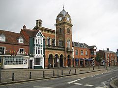
Hungerford is a historic market town and civil parish in Berkshire, England, 8 miles (13 km) west of Newbury, 9 miles (14 km) east of Marlborough, 27 miles (43 km) north-east of Salisbury and 60 miles (97 km) west of London. The Kennet and Avon Canal passes through the town alongside the River Dun, a major tributary of the River Kennet. The confluence with the Kennet is to the north of the centre whence canal and river both continue east. Amenities include schools, shops, cafés, restaurants, and facilities for the main national sports. Hungerford railway station is a minor stop on the Reading to Taunton Line.
- ^ "Hungerford". City population. Retrieved 25 October 2022.
