Back هانتر (نيويورك) Arabic بلده هانتر, الولايات المتحدة ARZ Гантер (Нью-Йорк) CE Hunter (lungsod sa Tinipong Bansa, New York) CEB Hunter, Efrog Newydd Welsh Hunter (Nueva York) Spanish Hunter (New York) Basque Hunter (New York) French Hunter, New York HT Hunter (New York) Italian
Hunter, New York | |
|---|---|
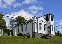
 Mary of the Mountain Church in Hunter | |
 Location in Greene County and the state of New York. | |
 Location of New York in the United States | |
| Coordinates: 42°12′31″N 74°12′50″W / 42.20861°N 74.21389°W | |
| Country | United States |
| State | New York |
| County | Greene |
| Government | |
| • Town supervisor | Sean Mahoney |
| • Town council | Members
|
| Area | |
| • Total | 90.21 sq mi (233.65 km2) |
| • Land | 89.89 sq mi (232.82 km2) |
| • Water | 0.32 sq mi (0.83 km2) |
| Population (2020) | |
| • Total | 3,035 |
| • Density | 34/sq mi (13/km2) |
| Time zone | UTC-5 (EST) |
| • Summer (DST) | UTC-4 (EDT) |
| ZIP code | 12442 |
| Area code | 518 |
| FIPS code | 36-039-36178 |
Hunter is a town located in Greene County, New York, United States. The population was 3,035 at the time of the 2020 census.[3][4] The town contains two villages, one named Hunter on the west, and the second called Tannersville, as well as a number of hamlets such as Haines Falls, Platte Clove, Lanesville and Edgewood. Additionally, there are three residential parks location within town limits: Onteora Park, Twilight Park and Elka Park. The town is on the southern border of Greene County and abuts the towns of Woodstock and Saugerties, located in Ulster County.
- ^ "2016 U.S. Gazetteer Files". United States Census Bureau. Retrieved July 5, 2017.
- ^ Cite error: The named reference
USCensusEst2016was invoked but never defined (see the help page). - ^ "Geographic Identifiers: 2010 Demographic Profile Data (G001): Hunter town, Greene County, New York". American Factfinder. U.S. Census Bureau. Retrieved December 29, 2016.[dead link]
- ^ U.S. Census Bureau, 2020 census results. https://www.census.gov/search-results.html?searchType=web&cssp=SERP&q=Hunter%20town,%20Greene%20County,%20New%20York