Back هانتيغتون (ماساتشوستس) Arabic هانتيجتون ARZ Huntington (Massachusetts) Catalan Гантингтон (Массачусетс) CE Huntington, Massachusetts Welsh Huntington (Massachusetts) Spanish Huntington (Massachusetts) Basque هانتینگتون، ماساچوست Persian Huntington (Massachusetts) French Huntington, Massachusetts HT
Huntington | |
|---|---|
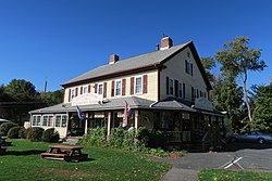
 Former Huntington Country Store | |
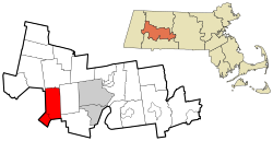
 Location in Hampshire County in Massachusetts | |
| Coordinates: 42°14′10″N 72°52′35″W / 42.23611°N 72.87639°W | |
| Country | United States |
| State | Massachusetts |
| County | Hampshire |
| Settled | 1769 |
| Incorporated (Norwich) | 1775 |
| Incorporated (Huntington) | March 5, 1855 |
| Government | |
| • Type | Open town meeting |
| Area | |
| • Total | 26.8 sq mi (69.4 km2) |
| • Land | 26.3 sq mi (68.2 km2) |
| • Water | 0.5 sq mi (1.2 km2) |
| Elevation | 382 ft (116 m) |
| Population (2020) | |
| • Total | 2,094 |
| • Density | 78/sq mi (30/km2) |
| Time zone | UTC-5 (Eastern) |
| • Summer (DST) | UTC-4 (Eastern) |
| ZIP Code | 01050 |
| Area code | 413 |
| FIPS code | 25-31785 |
| GNIS feature ID | 0618203 |
| Website | www |
Huntington is a town in Hampshire County, Massachusetts, United States. The population was 2,094 at the 2020 census.[1] It is part of the Springfield, Massachusetts Metropolitan Statistical Area.
The main village of Huntington is in the south of the town, with the villages of Norwich[2] and Norwich Bridge in the center. (The villages are unofficial neighborhoods representing clusters of buildings in an otherwise rural town.)
The villages of Knightville (or Knightsville) and Indian Hollow toward the north were removed by the construction of the Knightville Dam from 1939 to 1941.[3]

