Back نهر هون ARZ Хюон Bulgarian Huon River (suba) CEB Huon River German Huon (fleuve) French Kogin Huon Hausa ჰუონი Georgian Хьюон йогы MRJ Huon (elv) NB Huon (rzeka) Polish
| Huon River Taloonne | |
|---|---|
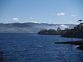
 Lower reaches of the Huon River in winter | |
| Etymology | Jean-Michel Huon de Kermadec, a French explorer |
| Native name | Taloonne (Southeast Tasmanian) |
| Location | |
| Country | Australia |
| State | Tasmania |
| Region | South-west, South-east Tasmania |
| Cities | Judbury, Ranelagh, Huonville, Franklin, Cygnet (Port Cygnet) |
| Physical characteristics | |
| Source | Marsden Range |
| • location | Southwest National Park below Junction Hill |
| • coordinates | 42°54′S 146°20′E / 42.900°S 146.333°E |
| • elevation | 578 m (1,896 ft) |
| Mouth | D'Entrecasteaux Channel |
• location | Surveyors Bay |
• coordinates | 43°16′52″S 147°6′51″E / 43.28111°S 147.11417°E |
| Length | 174 km (108 mi) |
| Width | |
| • maximum | 5 kilometres (3.1 mi) |
| Depth | |
| • average | 3 metres (9.8 ft) |
| • maximum | 12 metres (39 ft) |
| Basin features | |
| Tributaries | |
| • left | Weld River, Russell River, Little Denison River, Mountain River |
| • right | Anne River, Cracroft River, Picton River, Arve River |
| National park | Southwest National Park |
| [1] | |
The Huon River (/ˈhjuːɒnˈrɪvə/ HYOO-on-RIV-ə, Mellukerdee/palawa kani: Taloonne)[2] is a perennial river located in the south-west and south-east regions of Tasmania, Australia. At 174 kilometres (108 mi) in length, the Huon River is the fifth-longest in the state, with its course flowing east through the fertile Huon Valley and emptying into the D'Entrecasteaux Channel, before flowing into the Tasman Sea.
At its mouth, the Huon River is over 5 kilometres (3.1 mi) wide, and in the lower reaches, the river's average depth is 3 metres (9.8 ft), with maximum depths of up to 12 metres (39 ft). The Egg Islands, located in this lower tidal zone, serve as a significant ecological area due to their rich wetlands and birdlife.[3]
The Huon River was historically a transportation route for early settlers, the timber industry, and agricultural goods. The development of roads in the Huon Valley over the 19th century eventually overtook the river as the primary transport route.[4]
- ^ "Map of Huon River, TAS". Bonzle Digital Atlas of Australia. 2015. Retrieved 30 June 2015.
- ^ Plomley, NJB; Robinson, George Augustus (2008). Friendly Mission, the Tasmanian journals and papers of George Augustus Robinson. Hobart: Quintus. ISBN 9780977557226.
- ^ "Reconciliation Action Plan". Huon Valley Council. Retrieved 19 October 2024.
- ^ "Roads". Companion to Tasmanian History. University of Tasmania. Retrieved 19 October 2024.
