Back نهر هون ARZ Хюон Bulgarian Huon River (suba) CEB Huon River German Huon (fleuve) French Kogin Huon Hausa ჰუონი Georgian Хьюон йогы MRJ Huon (rzeka) Polish Хьюон (река) Russian
| Huon River Taloonne[1] | |
|---|---|
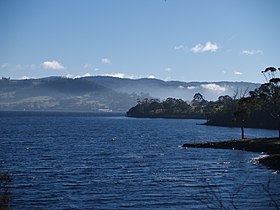
 Lower reaches of the Huon River in winter | |
| Etymology | Jean-Michel Huon de Kermadec, a French explorer |
| Location | |
| Country | Australia |
| State | Tasmania |
| Region | South-west, South-east Tasmania |
| Cities | Judbury, Ranelagh, Huonville, Franklin, Cygnet (Port Cygnet) |
| Physical characteristics | |
| Source | Marsden Range |
| • location | Southwest National Park below Junction Hill |
| • coordinates | 42°54′S 146°20′E / 42.900°S 146.333°E |
| • elevation | 578 m (1,896 ft) |
| Mouth | D'Entrecasteaux Channel |
• location | Surveyors Bay |
• coordinates | 43°16′52″S 147°6′51″E / 43.28111°S 147.11417°E |
| Length | 174 km (108 mi) |
| Basin features | |
| Tributaries | |
| • left | Weld River, Russell River, Little Denison River, Mountain River |
| • right | Anne River, Cracroft River, Picton River, Arve River |
| National park | Southwest National Park |
| [2] | |
The Huon River is a perennial river located in the south-west and south-east regions of Tasmania, Australia. At 174 kilometres (108 mi) in length, the Huon River is the fifth-longest in the state, with its course flowing east through the fertile Huon Valley and emptying into the D'Entrecasteaux Channel, before flowing into the Tasman Sea.
- ^ Plomley, NJB; Robinson, George Augustus (2008). Friendly Mission, the Tasmanian journals and papers of George Augustus Robinson. Hobart: Quintus. ISBN 9780977557226.
- ^ "Map of Huon River, TAS". Bonzle Digital Atlas of Australia. 2015. Retrieved 30 June 2015.
