Back Hurrungane Catalan Hurrungane CEB Hurrungane Danish Hurrungane German Hurrungane Spanish Hurrungane French Hurrungane-hegység Hungarian Hurrungane Italian Hurrungane LLD Hurrungane Dutch
| Hurrungane | |
|---|---|
| Hurrungene, Hurrungadn, Horungane | |
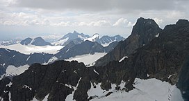
 Hurrungane seen looking towards the west. Store Skagastølstind is the highest peak visible. | |
| Highest point | |
| Peak | Store Skagastølstind, Luster/Årdal, Norway |
| Elevation | 2,405 m (7,890 ft) |
| Coordinates | 61°27′41″N 07°52′17″E / 61.46139°N 7.87139°E |
| Geography | |
| Location | Vestland, Norway |
| Range coordinates | 61°26′58″N 7°50′36″E / 61.4495°N 7.8434°E[1] |
| Parent range | Jotunheimen |
Hurrungane (also written Hurrungene, Hurrungadn, Horungane) is a mountain range in the municipalities Luster and Årdal in Vestland county, Norway. The area is southwest in the larger mountain range Jotunheimen and is also part of Jotunheimen National Park.[2]
The range has some of the most alpine peaks in Norway, and has 23 peaks over 2,000 metres (6,600 ft) (counting peaks with larger prominence than 30 metres or 98 feet). Several of the peaks are only accessible through climbing or glacier crossings. The starting point for hiking is the village of Turtagrø along the national tourist road, Sognefjellsvegen (RV55).
The highest peaks in the area are
- Store Skagastølstinden (Storen): 2,405 m or 7,890 ft
- Store Styggedalstinden: 2,387 m or 7,831 ft
- Jervvasstind (Gjertvasstind): 2,351 m or 7,713 ft
- Sentraltind: 2,348 m or 7,703 ft
- Vetle Skagastølstind: 2,340 m or 7,680 ft
- Midtre Skagastølstind: 2,284 m or 7,493 ft
- Skagastølsnebbet: 2,222 m or 7,290 ft
- Store Austanbotntind: 2,202 m or 7,224 ft
- ^ "Hurrungane, Luster (Vestland)" (in Norwegian). yr.no. Retrieved 2020-01-07.[permanent dead link]
- ^ Store norske leksikon. "Hurrungane" (in Norwegian). Retrieved 2010-09-10.

