Back هورت (فيرجينيا) Arabic هورت ARZ Hurt (Virgínia) Catalan Герт (Виргини) CE Hurt CEB Hurt, Virginia Welsh Hurt (Virginia) Spanish Hurt (Virginie) French Hurt, Vijini HT Hurt (Virginia) Italian
Hurt, Virginia | |
|---|---|
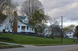
 Houses on Prospect Road | |
 Location of Hurt, Virginia | |
| Coordinates: 37°5′42″N 79°17′54″W / 37.09500°N 79.29833°W | |
| Country | United States |
| State | Virginia |
| County | Pittsylvania |
| Government | |
| • Type | Council-Manager |
| • Mayor | Gary Hodnett |
| • Town Council | Bob Majure Gary Poindexter Paul Johnson Michael Blackstock Kathy Keesee Steve Worley |
| Area | |
| • Total | 3.51 sq mi (9.10 km2) |
| • Land | 3.48 sq mi (9.00 km2) |
| • Water | 0.04 sq mi (0.09 km2) |
| Elevation | 748 ft (228 m) |
| Population (2010) | |
| • Total | 1,267 |
| • Estimate (2020)[2] | 1,267 |
| • Density | 364.08/sq mi (141/km2) |
| Time zone | UTC-5 (Eastern (EST)) |
| • Summer (DST) | UTC-4 (EDT) |
| ZIP code | 24563 |
| Area code | 434 |
| FIPS code | 51-39224[3] |
| GNIS feature ID | 1468433[4] |
| Website | www |
Hurt is a town in Pittsylvania County, Virginia, United States. Population was 1,269 at the 2020 census. It is included in the Danville, Virginia Metropolitan Statistical Area.
- ^ "2019 U.S. Gazetteer Files". United States Census Bureau. Retrieved August 7, 2020.
- ^ "Population and Housing Unit Estimates". United States Census Bureau. May 24, 2020. Retrieved May 27, 2020.
- ^ "U.S. Census website". United States Census Bureau. Retrieved 2008-01-31.
- ^ "US Board on Geographic Names". United States Geological Survey. 2007-10-25. Retrieved 2008-01-31.
