Back Incomappleux River CEB Incomappleux River German انڪوماپلاء درياھ Sindhi Incomappleux River Swedish انکوماپلاء دریا Urdu
| Incomappleux River | |
|---|---|
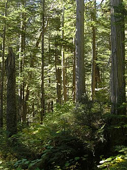
 Incomappleux inland rainforest | |
| Location | |
| Country | Canada |
| Province | British Columbia |
| District | Kootenay Land District |
| Physical characteristics | |
| Source | Illecillewaet Neve |
| • location | Selkirk Mountains |
| Mouth | Columbia River |
• location | Upper Arrow Lake |
• coordinates | 50°44′48″N 117°42′47″W / 50.74667°N 117.71306°W[1] |
| Basin size | 1,020 km2 (390 sq mi)[2] |
| Discharge | |
| • location | near Beaton[2] |
| • average | 55.8 m3/s (1,970 cu ft/s)[2] |
| • minimum | 4.76 m3/s (168 cu ft/s) |
| • maximum | 570 m3/s (20,000 cu ft/s) |
| Basin features | |
| Progression | Incomappleux Valley |
The Incomappleux River is in the West Kootenay region of southeastern British Columbia, Canada. Entering the Beaton Arm of Upper Arrow Lake, the river is a major tributary of the Columbia River. The upper reaches of the Incomappleux valley are home to some of the only inland temperate rainforest in the world.
The area has been studied since 2000 by Valhalla Wilderness Society as a part of their Inland Temperate Rainforest campaign, and the upper Incomappleux was included in the Selkirk Mountain Caribou Park proposal after groundbreaking biodiversity research by biologists Toby Spribille and Curtis Björk, sponsored by Valhalla Wilderness Society, found over 300 species of lichens in the Incomappleux, most of them in the ancient forest. This included seven species new to science. The Incomappleux Valley has been the subject of two films, one by Riel Marquardt, and more recently the VWS film Primeval: Enter the Incomappleux, by award winning documentary filmmaker, Damien Gillis. VWS Director Craig Pettitt and biologist Amber Peters toured the province with the film. The Incomappleux Valley was declared a conservancy in 2023 but the remainder of the Selkirk Mountain Caribou Park proposal, containing critical old growth inland rainforest corridors still remains unprotected. The valley is in the traditional territory of the Sinixt First Nation and its protection was supported by the autonomous Sinixt.
- ^ "Incomappleux River". BC Geographical Names.
- ^ a b c "Archived Hydrometric Data Search". Water Survey of Canada. Archived from the original on February 21, 2009. Retrieved October 19, 2008. Search for Station 08NE001 Incomappleux River near Beaton
