Back Ingleton (lungsod sa Hiniusang Gingharian, North Yorkshire, lat 54,15, long -2,47) CEB Ingleton German Ingleton Spanish اینگلتون، یورکشر شمالی Persian Ingleton (Yorkshire du Nord) French Ingleton (North Yorkshire) Polish Ingleton, North Yorkshire Swedish Ingleton, North Yorkshire Turkish
| Ingleton | |
|---|---|
| Village | |
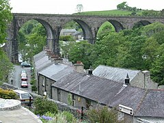
 Ingleton and the viaduct across Swilla Glen | |
Location within North Yorkshire | |
| Population | 2,186 (2011 census)[1] |
| OS grid reference | SD691729 |
| • London | 205 mi (330 km) SE |
| Civil parish |
|
| Unitary authority | |
| Ceremonial county | |
| Region | |
| Country | England |
| Sovereign state | United Kingdom |
| Post town | CARNFORTH |
| Postcode district | LA6 |
| Dialling code | 015242 |
| Police | North Yorkshire |
| Fire | North Yorkshire |
| Ambulance | Yorkshire |
| UK Parliament | |
Ingleton is a village and civil parish in North Yorkshire, England. The village is 17 miles (27 km) from Kendal and 17 miles (27 km) from Lancaster on the western side of the Pennines. It is 9 miles (14 km) from Settle. The River Doe and the River Twiss meet to form the source of the River Greta, a tributary of the River Lune. The village is on the A65 road and at the head of the A687. The B6255 takes the south bank of the River Doe to Ribblehead and Hawes. All that remains of the railway in the village is the landmark Ingleton Viaduct.[2] Arthur Conan Doyle was a regular visitor to the area and was married locally, as his mother lived at Masongill from 1882 to 1917 (see notable people). It has been claimed that there is evidence that the inspiration for the name Sherlock Holmes came from here.[3]
Whernside, 6 miles (9.7 km) north-north-east of the village, one of the Yorkshire Three Peaks, is the highest point in the parish at 736 metres (2,415 ft).
There are major quarries within the parish. Ingleton Quarry is active, Meal Bank Quarry no longer is, but extracted Carboniferous limestone and possesses an early Hoffman kiln. There was a textile mill, and the coalfield supported twelve or more small collieries, but Ingleton is mostly known for its tourism, being partially in the Yorkshire Dales National Park, offering waterfalls in a SSSI, limestone caves and Karst landscape walking opportunities.
- ^ Cite error: The named reference
2011 censuswas invoked but never defined (see the help page). - ^ OS map 98, Wensleydale and Upper Wharfedale.
- ^ Tunningley, Alan (11 July 2015). "Dales link to Sherlock Holmes' creation". The Westmorland Gazette. Retrieved 6 December 2015.
