Back اینورمر AZB Invermere CEB Invermere German اینورمیر Persian Invermere French Invermere Italian Invermere NB Invermere, British Columbia Romanian Invermere Swedish Інвермір Ukrainian
Invermere | |
|---|---|
| District of Invermere[1] | |
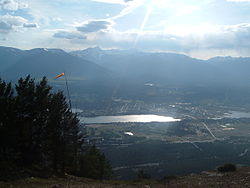
 Invermere, British Columbia, with Mount Nelson in the distance | |
 Location of Invermere, British Columbia | |
| Coordinates: 50°30′30″N 116°01′49″W / 50.50833°N 116.03028°W | |
| Country | Canada |
| Province | British Columbia |
| Region | East Kootenay |
| Incorporated | 1951 |
| Government | |
| • Governing body | Invermere Council |
| • MP | Rob Morrison |
| • MLA | Doug Clovechok |
| Area | |
| • Land | 10.75 km2 (4.15 sq mi) |
| • Urban | 3.44 km2 (1.33 sq mi) |
| Elevation | 859 m (2,818 ft) |
| Population (2021)[2] | |
| • District municipality | 3,917 |
| • Density | 364.4/km2 (944/sq mi) |
| • Urban | 3,340 |
| • Urban density | 971.4/km2 (2,516/sq mi) |
| Time zone | UTC-7 (Mountain Standard (MST)) |
| • Summer (DST) | UTC-6 (Mountain Daylight (MDT)) |
| Postal code span | V0A 1K0, V0A 1K7 |
| Area code | 250 / 778 / 236 |
| Highways | |
| Waterways | Columbia River, Windermere Lake |
| Website | invermere |
Invermere is a community in eastern British Columbia, Canada, near the border of Alberta. It is the hub of the Columbia Valley between Golden to the north and Cranbrook to the south. Invermere sits on the northwest shore of Windermere Lake and is a popular summer destination for visitors and second home owners from Edmonton and Calgary.
- ^ "British Columbia Regional Districts, Municipalities, Corporate Name, Date of Incorporation and Postal Address" (XLS). British Columbia Ministry of Communities, Sport and Cultural Development. Archived from the original on July 13, 2014. Retrieved November 2, 2014.
- ^ a b "Population and dwelling counts, for Canada, provinces and territories, and census subdivisions (municipalities), 2021 census – 100% data (British Columbia)". Statistics Canada. February 9, 2022. Retrieved February 9, 2022.